
The earth hasn’t stopped moving beneath the Molucca Sea. On April 2, a magnitude 5.8 aftershock struck 121 kilometers west-northwest of Ternate, Indonesia, according to USGS data—marking the 38th seismic event to rattle this restless patch of ocean in just seven days. The tremor came as the latest punch in an extraordinary swarm that began with a powerful magnitude 7.8 mainshock, turning this remote corner of the Indonesian archipelago into one of the most active seismic zones on the planet this week.
Why Is This Region Shaking So Violently?
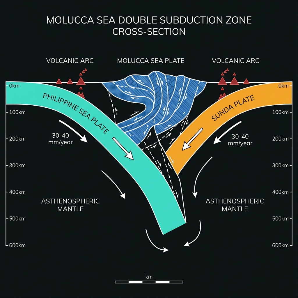
The Molucca Sea sits at one of the planet’s most complex geological intersections—a rare “double subduction” zone where tectonic forces converge from both east and west. Here, the Philippine Sea Plate dives beneath the Molucca Sea Plate while simultaneously the Sunda Plate (carrying much of Indonesia) subducts beneath it from the opposite direction. This creates a tectonic vice that is slowly consuming the Molucca Sea Plate from both sides, accumulating stress at rates of roughly 30 to 40 millimeters per year.
This violent geology has written a long history of destruction. In 2007, a magnitude 7.5 earthquake struck just 18 kilometers from today’s epicenter, killing four people and damaging hundreds of buildings across North Maluku. Eighteen years earlier, in 1986, another M7.5 event ruptured nearby. The current sequence mirrors these historical events in location and mechanism, suggesting the M7.8 mainshock may have relieved stress on the same fault system that produced those earlier giants. Seismologists classify this as a highly oblique convergent boundary, where the collision isn’t head-on but angled, creating complex strike-slip and thrust components that make predicting exact rupture patterns particularly challenging.
| Event | Magnitude | Depth | Distance from Ternate | Year |
|---|---|---|---|---|
| March Mainshock | M7.8 | 10 km | 119 km WNW | 2026 |
| Today’s Aftershock | M5.8 | 35 km | 121 km WNW | 2026 |
| 2007 Earthquake | M7.5 | ~20 km | 126 km WNW | 2007 |
| 1986 Earthquake | M7.5 | ~33 km | 146 km NW | 1986 |
| 2019 Earthquake | M7.1 | ~20 km | 141 km NW | 2019 |
What Does 35 Kilometers Deep Actually Mean?
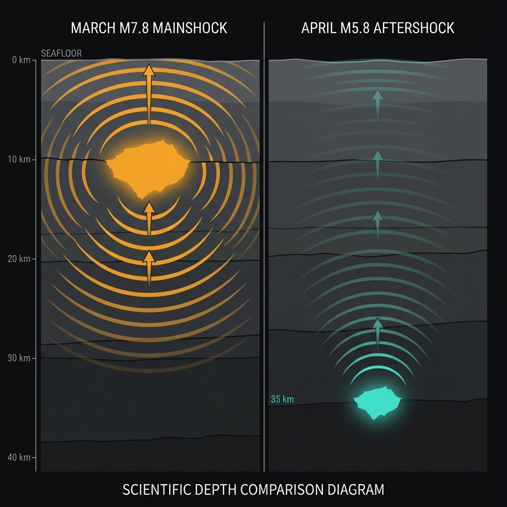
At 35 kilometers depth, Thursday’s M5.8 aftershock sits at the boundary between shallow crustal fracturing and the deeper ductile zone where rock begins to flow rather than snap. This intermediate depth means the earthquake’s energy had to travel through 35 kilometers of rock before reaching the seafloor, attenuating some of its destructive potential compared to the shallow M7.8 mainshock that ruptured at just 10 kilometers depth.
To grasp the difference, imagine dropping a stone in a pool: the shallow mainshock was like a large stone dropped from just above the surface—sending ripples far and wide with little energy loss—while today’s aftershock was dropped from deeper underwater, creating smaller surface waves. Residents in Ternate, 121 kilometers distant, likely registered the tremor as a gentle, rolling motion lasting several seconds, perhaps swaying hanging plants or rattling windows. Near the epicenter, however, the shaking would have been sharp enough to knock items from shelves. The energy release—roughly equivalent to 15,000 tons of TNT—reminds us that even “moderate” aftershocks in this sequence carry significant power.
What Should Residents Do Right Now?
For communities in North Maluku, the priority is maintaining situational awareness as this sequence continues. Residents should inspect buildings for new cracks or structural damage from the earlier M7.8 mainshock before entering, as aftershocks can cause weakened structures to collapse. Secure heavy furniture, water tanks, and gas cylinders immediately to prevent toppling during subsequent shakes. Keep emergency kits accessible with at least three days of supplies, and establish family communication plans that don’t rely on cellular networks, which can become overwhelmed during aftershock clusters. If you feel strong shaking, execute the drop, cover, and hold on protocol immediately—do not run outside, as falling debris from building facades poses the greatest immediate hazard. Continue monitoring official channels from Indonesia’s Meteorology, Climatology, and Geophysical Agency (BMKG) for localized tsunami warnings, though today’s event poses no tsunami threat due to its moderate size and strike-slip mechanism.
What Should We Watch For Next?
Seismologists expect this aftershock sequence to follow Omori’s Law, where the frequency of earthquakes decreases inversely with time, but the process could take months. While the rate of M5+ events will likely drop, the possibility remains for another significant earthquake in the M6 range, particularly as stress continues to redistribute along the complex fault networks of the Molucca Sea Collision Zone.
The greater concern is triggered seismicity on adjacent fault segments. The M7.8 mainshock may have loaded stress onto nearby structures such as the Sorong Fault system or other portions of the double subduction zone. If these stressed sections rupture, they could produce “triggered earthquakes” distinct from the aftershock sequence—new mainshocks in their own right. Residents should not interpret the decreasing frequency of shakes as a signal that the danger has passed. Instead, the region remains in a heightened state of seismic hazard until the crust fully adjusts to the massive stress redistribution caused by last week’s M7.8 rupture.
Frequently Asked Questions
How strong was this earthquake?
A magnitude 5.8 earthquake is considered moderate to strong. It released approximately 15 petajoules of energy—roughly equivalent to the atomic bomb dropped on Hiroshima, though spread over a much larger area and depth. At 121 kilometers from Ternate, residents would have experienced light to moderate shaking, rated as IV on the Modified Mercalli Intensity scale, meaning hanging objects would swing and windows might rattle, but structural damage would be unlikely.
Is there a tsunami risk from this aftershock?
No. According to USGS data, this earthquake poses no tsunami threat. While the mainshock M7.8 triggered tsunami warnings due to its shallow depth and thrust mechanism, today’s M5.8 aftershock occurred at 35 kilometers depth with insufficient vertical seafloor displacement to generate significant ocean waves. Indonesia’s BMKG has not issued tsunami advisories for this event.
Why has this area produced 38 earthquakes in one week?
This intense clustering represents a classic aftershock sequence following the March M7.8 mainshock. When a large earthquake ruptures a fault, it redistributes stress to surrounding rock, triggering smaller adjustments along the original rupture zone and nearby faults. The Molucca Sea’s complex double subduction zone—where two tectonic plates simultaneously dive beneath a third—creates a particularly unstable environment where stress redistribution happens frequently and violently.
Track this event live on the map!
Download GeoShake and get instant earthquake alerts.
Download GeoShake