
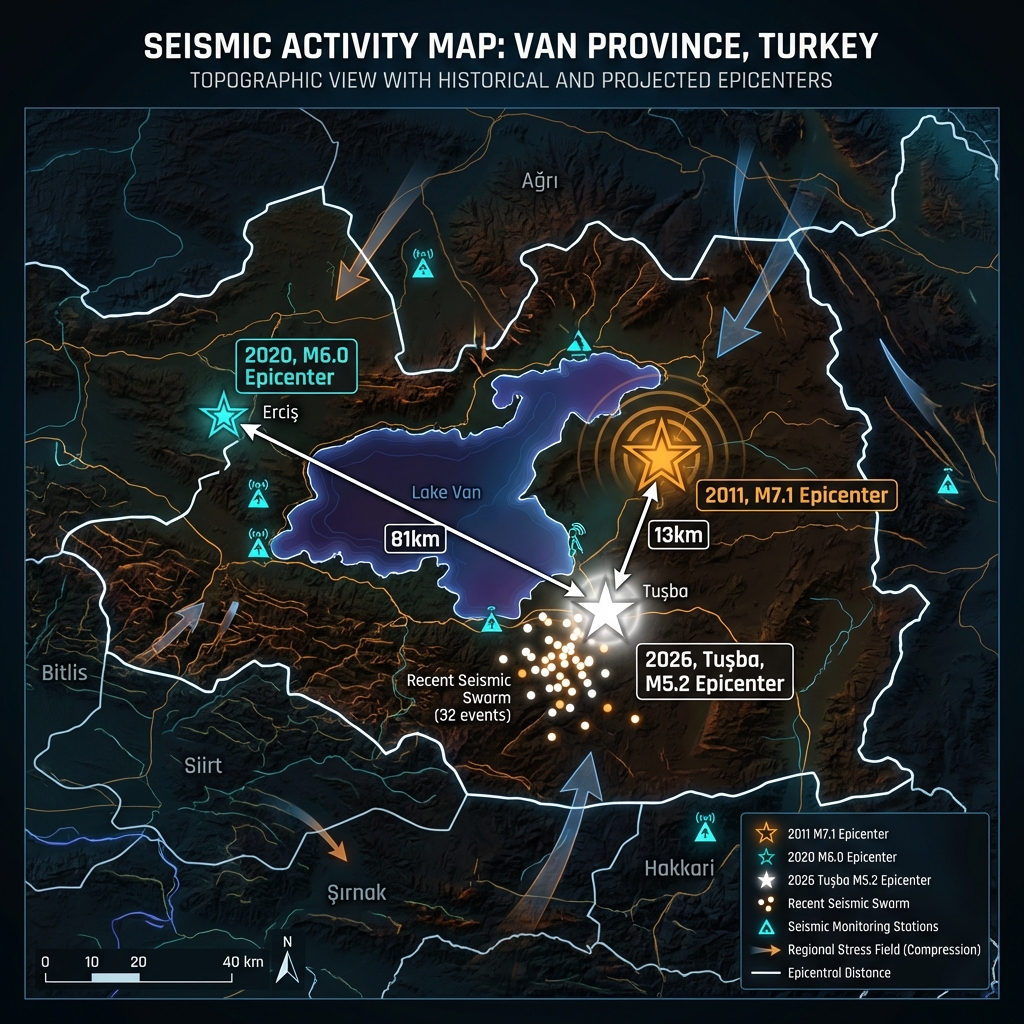
Thirteen kilometers. That is the hauntingly short distance separating the epicenter of Saturday morning’s shallow 5.2-magnitude tremor from the site of Turkey’s catastrophic 2011 Van earthquake, which claimed more than 600 lives. The latest shock struck at 05:52 UTC near Tuşba, in Turkey’s eastern Van Province, at a depth of just seven kilometers, according to USGS data, registering as the most powerful jolt in a persistent swarm that has produced 32 seismic events over the past seven days.
Why Is This Area So Seismically Active?
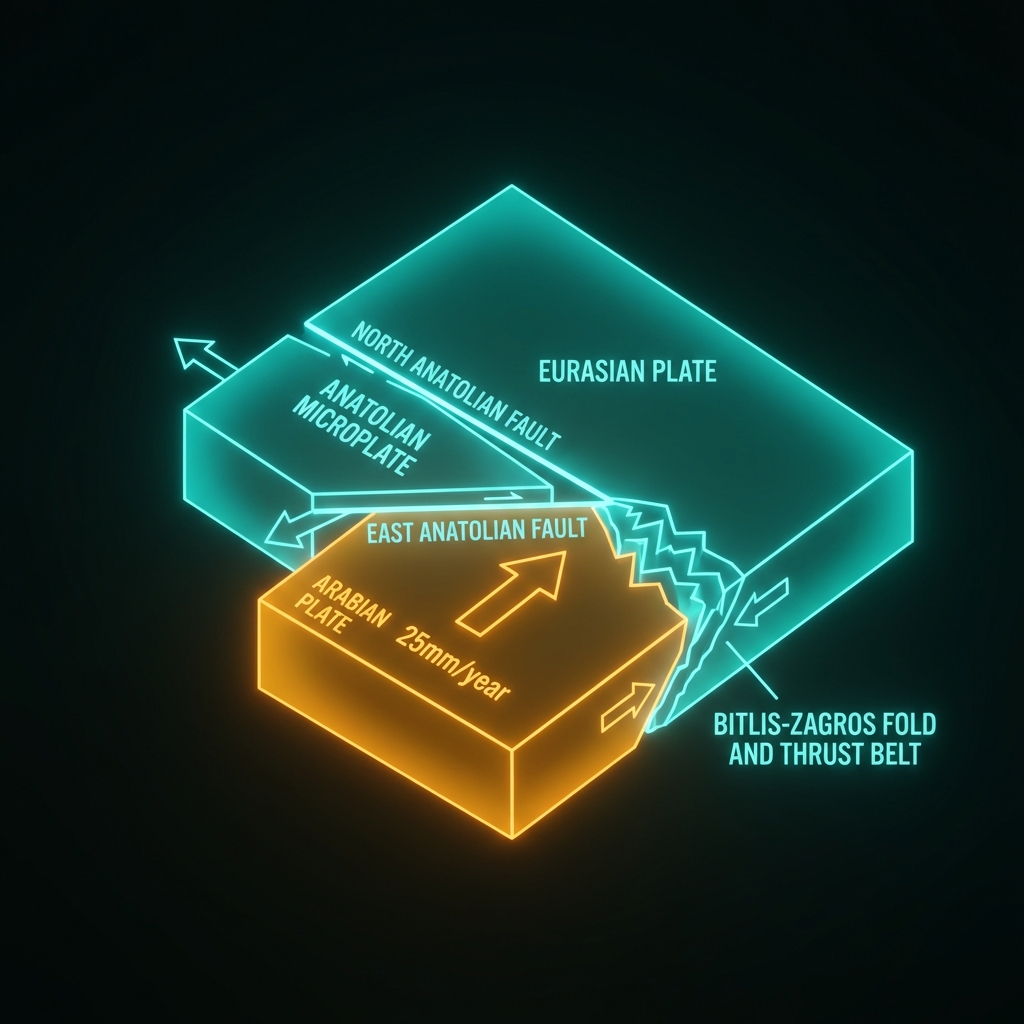
Eastern Turkey sits at one of the world’s most complex tectonic crossroads. Here, the northward-moving Arabian plate collides with the Eurasian plate at roughly 25 millimeters per year, forcing the Anatolian microplate westward like a geological wedge between two converging walls. The Van region lies near the intersection of the East Anatolian Fault and the North Anatolian Fault, yet Saturday’s tremor originated on a smaller, less understood fault system within the Bitlis-Zagros fold and thrust belt. This belt represents a zone of active crustal shortening where the Arabian plate is being shoved beneath Anatolia, creating a network of blind thrust faults and strike-slip structures that periodically release accumulated strain.
The proximity to the 2011 epicenter is particularly significant. That magnitude 7.1 event ruptured a previously unknown thrust fault beneath Lake Van, demonstrating that the region hosts substantial seismic potential hidden beneath relatively quiet surface geology. Seismologists classify this area as having high stress accumulation due to the ongoing continental collision, making it susceptible to both large mainshocks and prolonged aftershock sequences that can persist for years—or even decades—after major ruptures. The 2020 magnitude 6.0 event, which struck 81 kilometers to the southeast, further illustrates that stress redistribution across this fractured landscape continues to trigger significant earthquakes across a broad area.
What Does This Depth Mean for Shaking?
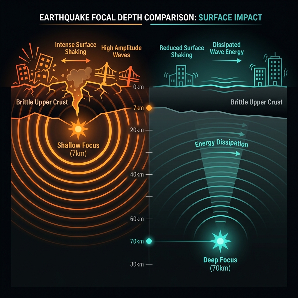
At seven kilometers depth, Saturday’s earthquake qualifies as extremely shallow—barely penetrating the Earth’s brittle upper crust. Seismologists classify earthquakes less than 70 kilometers deep as shallow, but those within the top ten kilometers produce disproportionately intense shaking at the surface because seismic energy has minimal distance to dissipate before reaching structures. The energy release from a 5.2-magnitude event at this depth can feel significantly more violent than a deeper quake of similar magnitude, much like the difference between standing next to a speaker versus hearing it from two rooms away.
The tremor was reportedly felt across Van Province and into neighboring regions, though no immediate major damage was reported from this specific event. To contextualize its power relative to the region’s history:
| Event | Date | Magnitude | Depth | Notable Impact |
|---|---|---|---|---|
| 2011 Van | Oct 23, 2011 | 7.1 | 18 km | 604 fatalities, thousands injured |
| 2020 Özalp | Jun 14, 2020 | 6.0 | 10 km | Moderate damage, 1 fatality |
| 2026 Tuşba | Apr 4, 2026 | 5.2 | 7 km | Strongest of current swarm |
A magnitude 5.2 releases roughly 20 times less energy than the 2011 magnitude 7.1 disaster, yet its shallow focus meant ground acceleration could still knock items from shelves and crack unreinforced masonry. The week-long swarm preceding it, which included 31 smaller tremors, illustrates the region’s current state of elevated seismicity—a common pattern when crustal blocks adjust to long-term tectonic pressures.
What Happens Next?
While Saturday’s 5.2-magnitude event represents the strongest tremor in the current sequence, it does not necessarily signal an impending larger earthquake. However, the clustering of 32 events in seven days demands careful monitoring. Seismologists will watch for patterns such as migration of hypocenters—subtle shifts in where the earthquakes originate—or changes in the ratio of small to large events, which can indicate whether stress is being released gradually or accumulating dangerously. The Turkish Disaster and Emergency Management Authority (AFAD) maintains dense seismic networks across eastern Anatolia, providing real-time data that can detect precursory swarms hours or days before potential major ruptures.
Historical context suggests vigilance is warranted. The 2011 magnitude 7.1 event was preceded by only modest seismic unrest, reminding scientists that major faults in this region can remain silent until catastrophic failure. Current models suggest the North Anatolian Fault’s eastern segments and the surrounding Bitlis-Zagros belt may be approaching critical stress states. For residents of Van Province, this swarm serves as a stark reminder of the region’s persistent hazard and the importance of earthquake-resistant construction in a landscape literally being squeezed between continents.
Frequently Asked Questions
How strong was this earthquake?
The tremor registered as magnitude 5.2 on the moment magnitude scale (Mw), making it a moderate but significant event. Its shallow depth of seven kilometers meant the shaking intensity at the surface likely reached VI on the Modified Mercalli Intensity scale, strong enough to be felt by everyone and potentially causing minor damage to poorly constructed buildings.
Is there a tsunami risk?
No tsunami warning was issued for this event. The earthquake occurred inland, approximately 13 kilometers from Lake Van—a large saline lake with limited connection to oceanic water bodies. Tsunami generation typically requires submarine thrust faulting or massive underwater landslides, neither of which apply to this shallow continental crustal rupture.
Why is this area so seismically active?
Eastern Turkey sits at the collision zone between the Arabian and Eurasian tectonic plates, where the Anatolian microplate is being forced westward. The Van region specifically lies within the Bitlis-Zagros fold and thrust belt, a zone of active mountain building and crustal shortening that generates frequent earthquakes as the Arabian plate subducts beneath Anatolia.
Track this event live on the map!
Download GeoShake and get instant earthquake alerts.
Download GeoShake