
Imagine standing on a tropical island when the ground beneath your feet lurches sharply, as if the earth itself has drawn a quick breath. That is precisely what residents of Yap State likely experienced on April 9, when a magnitude 5.1 earthquake struck the Federated States of Micronesia at a depth of just ten kilometers. According to USGS data, this shallow rupture concentrated its seismic energy frighteningly close to the surface, turning what seismologists classify as a moderate event into sharp jolts that would have reverberated through homes and across the low-lying atolls of this western Pacific archipelago.
Why Is This Corner of the Pacific So Restless?
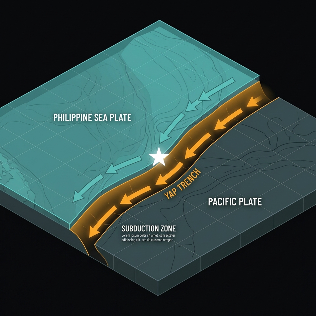
Yap sits astride one of the most complex tectonic boundaries on Earth. The island chain marks the meeting point of massive crustal plates—the Philippine Sea Plate grinding against the Pacific Plate—creating a zone of perpetual geological tension. This region forms part of the famed Ring of Fire, that horseshoe-shaped belt where roughly ninety percent of the world’s earthquakes originate as plates dive beneath one another in subduction zones or scrape past along transform faults.
The area is no stranger to significant shaking. In 2007, a magnitude 6.9 earthquake struck approximately 72 kilometers south of the Mariana Islands, releasing roughly eighty times more energy than today’s event. Three years later, in 2010, a magnitude 6.3 temblor rattled the region 149 kilometers from Yap. While these earlier quakes were stronger, their greater distance meant Yap residents felt them as distant rumbles rather than the sharp, localized jolt experienced today. Geologically, today’s earthquake represents the ongoing release of accumulated strain along fault systems associated with the nearby Yap Trench, where the Pacific Plate plunges westward beneath the Philippine Sea Plate.
What Does Ten Kilometers Mean for Island Residents?
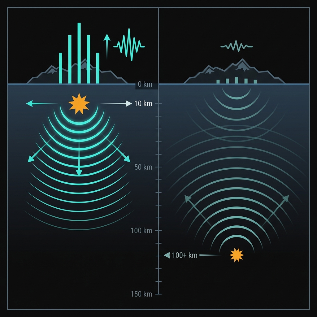
Depth is everything in seismology. When an earthquake ruptures at ten kilometers depth—what scientists classify as extremely shallow—the seismic waves have little time to spread out and lose energy before striking the surface. Imagine the difference between feeling an explosion directly beneath your feet versus one detonated miles underground; the shallow blast packs a far sharper punch. This phenomenon, known as near-source amplification, means a magnitude 5.1 at ten kilometers can produce shaking intensity comparable to a much deeper magnitude 6.0 event felt far from its source.
For context, consider how this event compares to the region’s historical significant earthquakes:
| Event | Magnitude | Distance from Yap | Estimated Impact |
|---|---|---|---|
| April 9, 2026 (Today’s) | 5.1 | 0 km (Direct) | Sharp, localized jolts |
| 2007 Mariana Islands | 6.9 | ~72 km south | Strong but attenuated |
| 2010 Guam region | 6.3 | ~149 km SSE | Moderate, distant rumble |
The table illustrates a crucial seismological principle: proximity often trumps magnitude. While the 2007 earthquake released vastly more total energy, its distance allowed that energy to dissipate across the oceanic crust before reaching Yap. Today’s shallow, nearby rupture delivered its energy directly to the island chain with minimal interference, potentially causing hanging objects to swing, unsecured items to topple, and residents to experience the dizzying sensation of sudden vertical acceleration typical of shallow island earthquakes.
What Should We Watch For Next?
Seismologists will monitor this region closely for the next several days, as shallow earthquakes of this magnitude often produce aftershocks—smaller tremors as the crust adjusts to the new stress configuration. Given the event’s shallow depth and moderate size, any subsequent quakes would likely follow similar patterns of sharp, short-duration shaking rather than the rolling motion associated with deeper, distant events. Fortunately, USGS analysis indicates no tsunami risk from this particular earthquake, as the vertical displacement of the seafloor was insufficient to displace a significant water column. For Yap’s residents, this event serves as a reminder that living atop an active plate boundary requires constant geological vigilance, even in paradise.
Frequently Asked Questions
How strong was this earthquake?
The earthquake registered as magnitude 5.1 on the moment magnitude scale, a moderate-sized event. However, because it occurred at a shallow depth of only ten kilometers directly beneath the island chain, the ground shaking would have felt significantly more intense than the number alone suggests, potentially reaching modified Mercalli intensity levels of VI (strong) in the immediate epicentral region.
Was there a tsunami risk?
No. According to USGS data, this earthquake did not generate a tsunami. The rupture mechanism and shallow depth did not produce sufficient vertical seafloor displacement to trigger ocean-wide waves. Yap State authorities and Pacific Tsunami Warning Center protocols confirmed no evacuation orders were necessary.
Why does Yap State experience earthquakes?
Yap State sits at the convergence of the Philippine Sea Plate and the Pacific Plate, forming part of the western Pacific’s active subduction zone. As these massive tectonic plates grind against each other and the Pacific Plate dives beneath the Philippine Sea Plate along the Yap Trench, accumulated stress periodically releases as earthquakes. This tectonic setting places the islands within the Pacific Ring of Fire, ensuring regular seismic activity.
Track this event live on the map!
Download GeoShake and get instant earthquake alerts.
Download GeoShake