
A magnitude 5.7 earthquake struck deep beneath the mountainous terrain of western New Guinea on March 26, 2026, sending tremors through a region still bearing the geological scars of two powerful magnitude 7.0 events that devastated nearby communities in 2015 and 2013. The tremor, which occurred at 10:51 PM UTC approximately 153 kilometers west-southwest of Abepura, Indonesia, ruptured at a depth of nearly 54 kilometers—positioning it unsettlingly close to the epicenters of those earlier destructive quakes, according to USGS data.
Why Is This Region So Prone to Major Earthquakes?
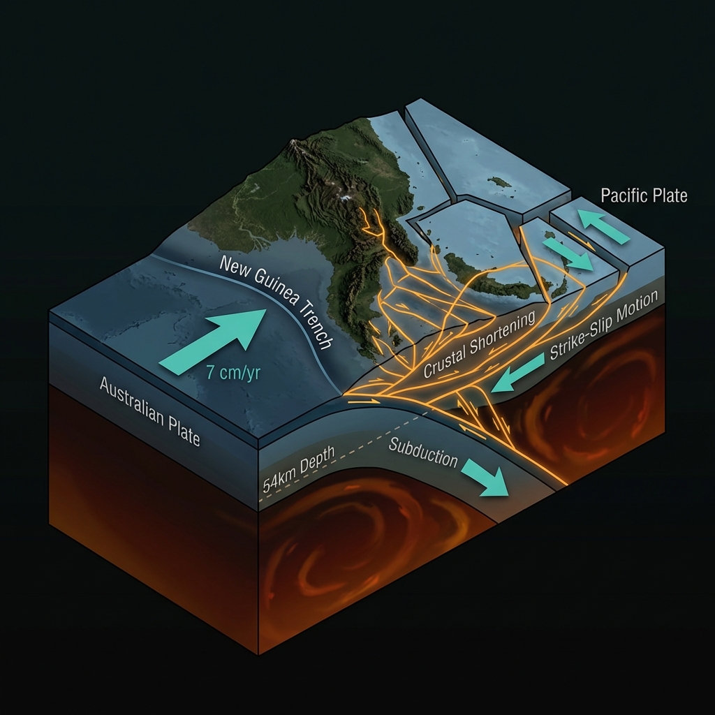
This corner of Indonesia sits at the chaotic intersection of the Australian and Pacific tectonic plates, where massive slabs of Earth’s crust collide with violent consequences. The ongoing convergence has created a complex web of thrust faults and strike-slip systems beneath Papua’s rugged interior, making the region one of the most seismically hazardous yet scientifically fascinating areas in Southeast Asia. Seismologists classify earthquakes here as the result of crustal shortening and strike-slip motion along the New Guinea trench system, where the Australian plate plunges northward beneath fragments of the Pacific plate at rates of several centimeters per year.
This relentless tectonic crunch has produced a startling frequency of significant events in recent decades, including a magnitude 6.8 tremor in 1986 that struck just 148 kilometers west of Abepura, and a magnitude 6.4 event as recently as 2025. The 2015 and 2013 earthquakes—both magnitude 7.0—serve as sobering reminders of the region’s capacity for destruction, collectively causing fatalities and rendering thousands homeless in remote highland communities. The proximity of Thursday’s event to those earlier epicenters—located just 113 and 107 kilometers away respectively—suggests this may represent continued stress redistribution along the same fault systems that ruptured catastrophically in years past.
How Did This Earthquake Compare to Previous Major Events?

While magnitude 5.7 qualifies as a moderate earthquake capable of causing localized damage, it releases roughly 250 times less energy than the magnitude 7.0 events that preceded it in this same vicinity. However, depth plays a crucial role in how these events are experienced: Thursday’s quake originated at 53.9 kilometers depth, classifying it as an intermediate-focus event that typically produces less intense surface shaking than shallow quakes of similar magnitude.
| Event | Magnitude | Distance from Abepura | Depth | Year |
|---|---|---|---|---|
| Current Event | 5.7 | 153 km | 54 km | 2026 |
| Previous Major | 7.0 | 234 km | Shallow | 2015 |
| Previous Major | 7.0 | 260 km | Shallow | 2013 |
| Historical Event | 6.8 | 148 km | Shallow | 1986 |
| Recent Event | 6.4 | 192 km | Shallow | 2025 |
To put this in perspective, the 2015 and 2013 events released energy equivalent to roughly 250 earthquakes of this size. Yet even a moderate magnitude 5.7 can prove dangerous in Papua’s rugged terrain, where steep slopes and loose volcanic soils become lethal during shaking. At 153 kilometers from Abepura, residents of the provincial capital likely experienced only light shaking—comparable to the sensation of a heavy truck passing nearby—while communities closer to the epicenter in the remote highlands may have felt moderate shaking capable of rattling dishes, disturbing sleep, and potentially cracking weak masonry.
What Should Residents Do Now?
Given the moderate magnitude and significant distance from major population centers, residents across the region should inspect their homes for new cracks in walls or foundations, secure any items that may have shifted during the shaking, and ensure emergency supplies remain stocked and accessible. While intermediate-depth earthquakes typically generate fewer aftershocks than shallow events, the proximity to the 2015 and 2013 rupture zones means residents should remain alert for several days, as this event could potentially trigger minor readjustments along nearby fault segments. Those in remote highland villages closest to the epicenter should avoid damaged structures and report any significant land cracking or water source disruptions to local authorities.
What Should We Monitor Going Forward?
Geoscientists will scrutinize aftershock patterns over the coming weeks to determine whether this event represents an isolated stress release or the beginning of a sequence similar to the prolonged aftershock campaigns that followed the 2015 and 2013 earthquakes. The region’s persistent activity—including magnitude 6+ events in 1986, 1987, 1998, and 2025—demonstrates that this area remains locked in a cycle of continuous tectonic adjustment. While no tsunami warning was issued due to the inland location and depth, GeoShake monitors will track any smaller tremors that might indicate migrating stress toward the more populated coastal regions or adjacent segments of the fault system that remain locked and loaded.
Frequently Asked Questions
How strong was this earthquake?
The earthquake registered as magnitude 5.7 on the moment magnitude scale, making it a moderate event capable of causing localized damage near the epicenter but unlikely to cause widespread destruction at the reported distance from populated areas.
Is there a tsunami risk?
No tsunami warning was issued for this event. The earthquake occurred at a depth of 54 kilometers and was located inland, far enough from the coast and deep enough to avoid displacing the seafloor in a way that would generate ocean waves.
How does this compare to the 2015 and 2013 earthquakes?
This magnitude 5.7 event released approximately 250 times less energy than the magnitude 7.0 earthquakes that struck the region in 2015 and 2013, though its proximity to those earlier epicenters—within roughly 110 kilometers—places it within the same active fault system.
Track this event live on the map!
Download GeoShake and get instant earthquake alerts.
Download GeoShake