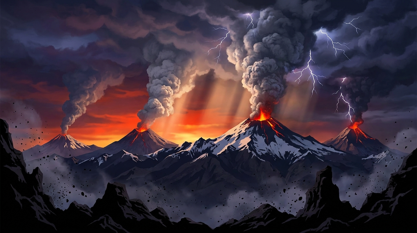
Volcanic activity remained elevated across the Pacific Ring of Fire and South American volcanic arcs during the past 24 hours, with monitoring networks recording 14 discrete events according to the Smithsonian Global Volcanism Program. Ash advisories dominated the landscape as explosive activity persisted at several stratovolcanoes in Peru, Ecuador, and Guatemala, sending volcanic plumes soaring between 4,600 and 6,700 meters into the atmosphere and prompting close coordination between volcanological observatories and aviation authorities.
Which Volcanoes Showed Significant Activity Today?
Four volcanoes generated notable ash emissions requiring formal advisories, while additional thermal anomalies and seismicity were detected at other monitored systems across Indonesia, the Philippines, and Japan.
Sabancaya (Peru) produced the highest ash column of the reporting period, with emissions reaching 6,700 meters (approximately 22,000 feet) above sea level according to data published at 17:45 UTC on April 18. The Volcano Discovery monitoring network, aggregating data from the Smithsonian Global Volcanism Program, classified this as an ash advisory event, though no specific aviation color code was assigned beyond “NOT GIVEN” in current bulletins. Sabancaya, located in the Andes of southern Peru, has maintained intermittent explosive activity throughout 2026, with ash fall periodically affecting agricultural zones in the Arequipa region.
Sangay (Ecuador) erupted with an ash column reaching 6,100 meters (20,000 feet), with the advisory issued at 02:30 UTC on April 19. This stratovolcano, one of Ecuador’s most active, produced emissions that drifted according to prevailing wind patterns, though specific dispersion vectors were not detailed in the preliminary report. Sangay’s remote location in the Cordillera Real limits ground-based observation, making satellite thermal detection and pilot reports critical for hazard assessment.
Fuego (Guatemala) generated two distinct entries in today’s activity log, including both a confirmed eruption and a subsequent ash advisory. The ash column reached 4,600 meters (15,100 feet) according to the 18:15 UTC bulletin on April 18. Fuego, Spanish for “fire,” is renowned for its persistent Strombolian activity and paroxysmal eruptions that frequently generate pyroclastic flows and ash fall affecting the Antigua Guatemala region and La Aurora International Airport operations.
Reventador (Ecuador) rounded out the significant ash-producing events with a column reaching 4,900 meters (16,100 feet), reported at 20:30 UTC on April 18. Located in the eastern Andes approximately 90 kilometers east of Quito, Reventador’s frequent explosions often go unobserved due to persistent cloud cover, requiring reliance on seismic networks and infrasound detectors to confirm eruptive episodes.
Additional monitored volcanoes contributing to today’s event count include Ibu (Indonesia), Mayon (Philippines), and Sakurajima (Japan), though specific eruption parameters for these systems were not detailed in the April 19 advisory cycle.
How Dangerous Are the Ash Emissions?
The ash clouds reported today present varying degrees of hazard depending on altitude, volume, and dispersion trajectories. Sabancaya’s 6,700-meter plume penetrates the lower stratosphere, where ash particles can remain suspended for extended periods and travel hundreds of kilometers from the source vent. At these altitudes, prevailing westerly winds could potentially carry fine ash toward populated valleys or aviation corridors connecting South American capitals.
Fuego’s 4,600-meter emissions, while lower than Sabancaya’s, intersect with critical commercial aviation flight levels between 30,000 and 40,000 feet, particularly affecting routes between North and South America. The silicic ash composition typical of Fuego’s magmatic system poses severe abrasion risks to jet turbine blades and can clog fuel systems if aircraft inadvertently fly through concentrated plumes. Ground-based ashfall from Fuego frequently impacts rural communities on the volcano’s southwestern flank, requiring respiratory precautions and potential agricultural protection measures.
What Should Aviation Authorities Know?
The current aviation color code for Sabancaya was listed as “NOT GIVEN” in today’s report, indicating either unassessed status or technical delays in coordination between the Instituto Geofísico del Perú (IGP) and the Buenos Aires Volcanic Ash Advisory Center (VAAC). This lack of designation does not indicate safety; rather, it suggests pilots and dispatchers should exercise enhanced vigilance when operating within 100 nautical miles of the volcano until formal color coding is established.
Sangay, Reventador, and Fuego all produced ash columns exceeding 4,500 meters, placing them firmly within the envelope of commercial flight operations. The Washington VAAC typically handles advisories for Central and South American volcanoes, and today’s reports would trigger the issuance of volcanic ash advisories (VAAs) and graphical ash dispersion forecasts. Aircraft encountering volcanic ash at these altitudes may experience engine flameout, loss of thrust, and pitot tube blockages, necessitating immediate 180-degree turns and altitude changes to exit ash clouds.
Are Communities at Risk from Pyroclastic Flows?
While today’s reports focus primarily on ash column heights rather than ground-based hazards, the eruption styles characteristic of these volcanoes warrant continuous monitoring for pyroclastic density currents. Fuego’s history of generating fast-moving pyroclastic flows during paroxysmal phases requires maintained exclusion zones within 10-15 kilometers of the summit crater, particularly in barrancas (drainages) that channel hot avalanches. Reventador’s steep cone morphology and frequent block-and-ash flows present similar threats to the sparse populations in the Amazonian foothills, though the remote location minimizes human exposure compared to Guatemala’s densely settled volcanic highlands.
Volcanic Activity Summary Table
| Volcano | Location | Event Type | Alert Level |
|---|---|---|---|
| Sabancaya | Peru | Ash Advisory | Not Specified |
| Sangay | Ecuador | Ash Advisory | Not Specified |
| Fuego | Guatemala | Ash Advisory / Eruption | Not Specified |
| Reventador | Ecuador | Ash Advisory | Not Specified |
| Ibu | Indonesia | Activity Detected | Not Specified |
| Mayon | Philippines | Activity Detected | Not Specified |
| Sakurajima | Japan | Activity Detected | Not Specified |
Frequently Asked Questions
What does an ash advisory mean for nearby residents?
An ash advisory indicates that a volcano has produced measurable volcanic ash emissions that may affect air quality, visibility, and infrastructure within the dispersion plume downwind of the vent. Residents should minimize outdoor activities, use N95 masks when ash fall occurs, protect water sources from contamination, and avoid driving if visibility drops below 100 meters; ash accumulation on roofs may require removal if exceeding 10 centimeters to prevent structural collapse, particularly when wet.
Why is volcanic ash dangerous to aircraft engines?
Volcanic ash consists of tiny, sharp silicate glass particles and minerals that melt when ingested into hot jet engines, coating turbine blades and combustors with a glassy layer that disrupts airflow and engine cooling; this can cause engine surge, flameout, and complete power loss within minutes of exposure. Even encounters with diluted ash clouds that don’t cause immediate engine failure can result in expensive damage to windshields, landing lights, and pitot tubes, requiring extensive maintenance inspections before aircraft return to service.
How do scientists determine ash column heights?
Volcanologists estimate ash column heights using a combination of ground-based Doppler radar, satellite thermal infrared imagery, visual observations from observatory webcams, and pilot reports (PIREPs), with satellite-based techniques like the Himawari-8 or GOES-16 split-window algorithm providing the most consistent measurements for remote volcanoes; these heights are reported above sea level (asl) rather than ground level, meaning a 6,000-meter column from a 4,000-meter-high volcano extends only 2,000 meters above the summit vent.
Track this event live on the map!
Download GeoShake and get instant earthquake alerts.
Download GeoShake