Global volcanic monitoring networks recorded 20 distinct eruptive events during the past 24 hours according to the Smithsonian Global Volcanism Program. Significant surface activity was confirmed at Piton de la Fournaise in the Indian Ocean and Mayon in the Philippines, while ash advisories were issued for high-altitude plumes originating from Sangay in Ecuador and Semeru in Indonesia. These events prompted immediate coordination between local geological surveys and international aviation authorities to assess hazards and reroute commercial air traffic.
Which Volcanoes Erupted Today?
Piton de la Fournaise (Réunion): The shield volcano commenced eruptive activity at approximately 04:15 UTC on April 14, 2026, according to monitoring data compiled by the Smithsonian Global Volcanism Program. Located on the French island of Réunion, this hotspot volcano represents one of the most productive basaltic systems globally, characterized by effusive lava flows rather than explosive Plinian events. The current eruption follows several months of elevated seismic tremor detected by the Piton de la Fournaise Volcano Observatory, consistent with magma ascent from the mantle plume beneath the island.
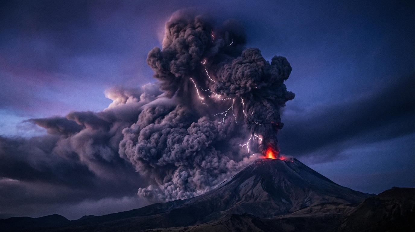
Mayon (Philippines): The Philippine Institute of Volcanology and Seismology (PHIVOLCS) confirmed eruptive activity beginning at 04:11 UTC on April 14. Mayon, renowned for its symmetrical conical profile rising 2,463 meters above Albay Province, generated volcanic emissions that triggered immediate hazard assessments for surrounding municipalities. The stratovolcano, which sits within the Bicol Arc of the Pacific Ring of Fire, maintains a historical pattern of producing pyroclastic density currents and lava flows that affect populations within the 6-kilometer permanent danger zone.
Fuego (Guatemala): Reporting indicated continued eruptive behavior at Volcán de Fuego, with activity registered at 21:00 UTC on April 13 according to the National Institute for Seismology, Volcanology, Meteorology and Hydrology (INSIVUMEH). This Central American stratovolcano, positioned approximately 40 kilometers southwest of Guatemala City, produced characteristic strombolian explosions accompanied by ballistic ejecta and lava fountains. The volcano’s frequent activity generates persistent ash fall that impacts agricultural communities in the departments of Escuintla, Sacatepéquez, and Chimaltenango.
Where Are Ash Advisories Currently Active?
Sangay (Ecuador): The Washington Volcanic Ash Advisory Center (VAAC) issued urgent alerts following an ash emission reaching 7,600 meters (24,900 feet) above mean sea level. The plume, reported at 22:45 UTC on April 13, presents significant aviation hazards as it intersects with commercial flight levels typically cruising between 9,000 and 12,000 meters. Sangay, one of Ecuador’s most active volcanoes situated within the Cordillera Real approximately 30 kilometers from Macas, maintains a remote location that makes ground-based monitoring challenging and satellite observations critical for aviation safety.
Semeru (Indonesia): Indonesia’s Center for Volcanology and Geological Hazard Mitigation (PVMBG) reported ash emissions extending to 4,900 meters (16,100 feet) altitude, prompting advisories from the Darwin VAAC. The advisory, timestamped 00:15 UTC on April 14, affects air traffic routes traversing East Java and the Flores Sea region. Semeru’s current activity demonstrates the volcano’s typical vulcanian eruption style, characterized by periodic ash column generation driven by gas pressure release within the summit crater, which currently contains an active lava dome.
What Other Volcanic Systems Show Elevated Activity?
Dukono (Indonesia): Continuous eruptive activity persists at this remote stratovolcano on Halmahera Island, where the twin craters produce frequent minor explosions and ash venting. PVMBG maintains the volcano under continuous surveillance due to its persistent ash emissions that periodically reach 2,000-3,000 meters altitude, affecting local aviation and air quality.
Reventador (Ecuador): Located in the eastern Andes approximately 90 kilometers east of Quito, this basaltic-andesite stratovolcano continues exhibiting thermal anomalies and seismic unrest detectable by satellite-based infrared sensors. The Ecuadorian Geophysical Institute reports ongoing crater incandescence and intermittent gas emissions suggesting continued magma replenishment within the volcanic conduit.
Canlaon (Philippines): PHIVOLCS monitors this Negros Island volcano for seismic swarms and ground deformation indicative of magmatic fluid movement. While no major eruption occurred during the reporting period, volcanic tremors and inflation of the edifice suggest pressure buildup that warrants elevated vigilance for communities on Negros Occidental and Negros Oriental.
Lewotobi (Indonesia): The twin volcano system in the Flores Sea region shows persistent thermal signatures and gas emissions from both the Laki-laki (male) and Perempuan (female) cones. Regional monitoring networks detect sulfur dioxide flux consistent with active degassing from shallow magma reservoirs.
Ibu (Indonesia): Situated on Halmahera, Ibu continues its decade-long eruptive episode characterized by lava dome growth, avalanches, and minor explosive events. The volcano produces frequent ash plumes that affect the island’s air quality and require ongoing hazard assessments for nearby villages.
Summary of Active Volcanoes
| Volcano | Location | Event Type | Alert Level |
|---|---|---|---|
| Piton de la Fournaise | Réunion, France | Eruption | Not Specified |
| Mayon | Philippines | Eruption | Not Specified |
| Fuego | Guatemala | Eruption | Not Specified |
| Sangay | Ecuador | Ash Advisory | Not Specified |
| Semeru | Indonesia | Ash Advisory | Not Specified |
| Dukono | Indonesia | Continuous Activity | Not Specified |
| Reventador | Ecuador | Thermal Anomaly | Not Specified |
| Canlaon | Philippines | Seismic Unrest | Not Specified |
| Lewotobi | Indonesia | Degassing | Not Specified |
| Ibu | Indonesia | Lava Dome Growth | Not Specified |
Data compiled from Smithsonian Global Volcanism Program, USGS, PHIVOLCS, PVMBG, and INSIVUMEH reports. Alert levels indicate current status as reported by respective monitoring agencies during the 24-hour observation window.
Frequently Asked Questions
What altitude do volcanic ash clouds need to reach before aviation advisories are issued?
Aviation Volcanic Ash Advisories are typically issued when ash plumes exceed flight levels that could affect commercial air traffic, generally beginning around 3,000 meters (10,000 feet) above ground level. Today’s reports of 7,600-meter and 4,900-meter columns at Sangay and Semeru respectively represent significant hazards, as these altitudes intersect with cruising levels for commercial jet aircraft which typically operate between 9,000 and 12,000 meters, potentially causing engine flameout and airframe damage upon ingestion of silicate particles.
How does Mayon’s current eruption compare to its historical activity?
Mayon Volcano typically produces short-duration explosive eruptions, lava flows, and pyroclastic density currents characteristic of stratovolcanoes within the Pacific Ring of Fire. The current eruptive episode follows months of elevated seismicity and ground inflation detected by PHIVOLCS monitoring networks, consistent with the volcano’s pattern of magmatic recharge prior to surface manifestation, though the specific explosivity index and duration will depend on continued gas release rates and magma supply from depth.
Which international agencies coordinate the volcanic ash warnings mentioned in today’s report?
The Smithsonian Global Volcanism Program consolidates reports from multiple Volcanic Ash Advisory Centers (VAACs) including Washington VAAC (covering Sangay), Darwin VAAC (covering Semeru and Indonesian volcanoes), and Toulouse VAAC (covering Piton de la Fournaise). Regional monitoring agencies including PHIVOLCS, PVMBG, and INSIVUMEH provide ground-based observations that validate satellite-derived ash detections using ground-based radar, visual cameras, and seismic networks to ensure comprehensive hazard assessment for both aviation and ground-based populations.
Track this event live on the map!
Download GeoShake and get instant earthquake alerts.
Download GeoShake