The past 24 hours have seen heightened volcanic unrest across the Pacific Ring of Fire, with monitoring agencies recording 26 distinct eruptive events according to the Smithsonian Global Volcanism Program. Major ash advisories dominate today’s report, led by Indonesia’s Semeru volcano which propelled ash columns to 4,600 meters altitude, while Guatemala’s Fuego and Santiaguito volcanoes generated significant ash plumes reaching 4,300 meters and 4,000 meters respectively. Japan’s Sakurajima also produced explosive eruptions, adding to a busy monitoring day for volcanologists and aviation authorities worldwide.
Which Volcanoes Erupted Today?
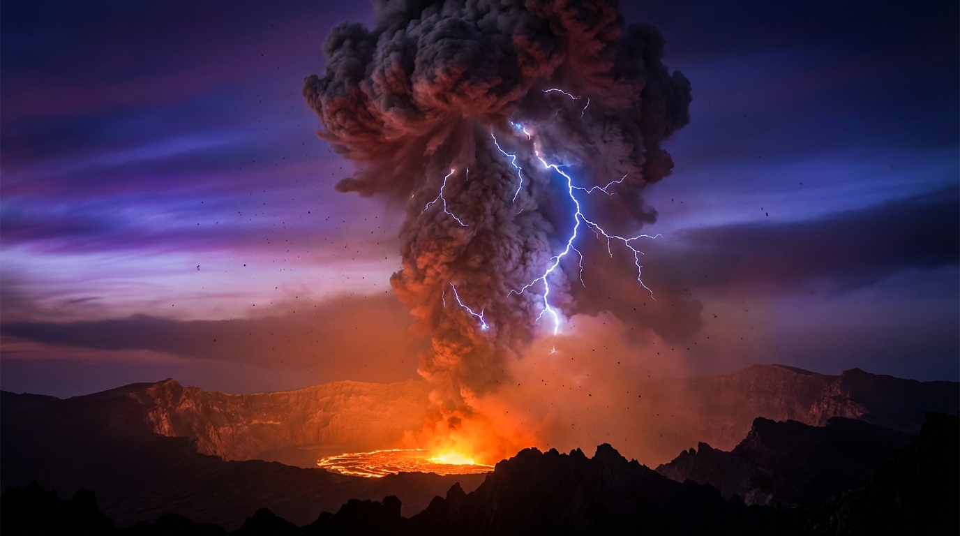
Sakurajima volcano, located on Kyushu Island in Japan, generated explosive eruptive activity detected by monitoring networks on April 12 at 17:36 UTC according to data compiled by the Smithsonian Global Volcanism Program. This highly active stratovolcano, known for frequent vulcanian eruptions, typically produces ash plumes, ballistic projectiles, and volcanic lightning during such events. While specific ash column heights were not immediately available in today’s preliminary reports, the eruption prompted local authorities to maintain elevated alert statuses for surrounding populations.
In Guatemala, the Santiaguito lava dome complex recorded a significant eruption event on April 12, marking one of the most substantial events in Central America during this reporting period. Located in the western highlands of Guatemala, Santiaguito has maintained continuous dome growth and explosive activity for nearly a century, frequently producing pyroclastic flows and ash emissions that impact local agriculture and nearby communities. Today’s eruption represents the latest in a series of dome-collapse events that characterize this persistently active volcanic system.
Where Are the Highest Ash Clouds Rising?
Semeru volcano in East Java, Indonesia, generated the highest ash plume of the past 24 hours, with an ash advisory issued for an eruption reaching 4,600 meters (approximately 15,090 feet) above sea level according to monitoring data published on April 13 at 00:00 UTC. This altitude places volcanic ash directly into commercial aviation flight corridors, specifically affecting air routes between Australia and Asia. Semeru, the highest volcano on Java, has maintained heightened activity since its major eruption in December 2021, with current ash emissions likely representing vulcanian explosions from the growing Jonggring Seloko crater.
Fuego volcano in Guatemala produced an ash advisory on April 12 at 20:15 UTC, with volcanic ash detected at 4,300 meters (14,100 feet) altitude extending downwind from the summit. This stratovolcano, located approximately 40 kilometers southwest of Guatemala City, remains one of Central America’s most active volcanoes, characterized by persistent Strombolian activity and occasional paroxysmal eruptions. The current ash column poses immediate hazards to aviation traffic traversing Central American airspace, particularly flights operating between North and South America.
Santiaguito contributed a second significant ash advisory on April 12 at 12:45 UTC, with ash emissions reaching 4,000 meters (13,100 feet) altitude. This separate ash event from the earlier eruption highlights the volcano’s capacity for sustained explosive activity affecting both local populations and regional aviation. The dual nature of today’s activity—both eruptive and ash-producing—underscores the complex hazard profile presented by dome-building volcanoes in tropical environments.
What Other Volcanic Systems Are Under Watch?
Beyond the highlighted ash advisories, monitoring networks continue to track activity at sixteen distinct volcanic systems worldwide. In Indonesia, Lewotolo, Lewotobi, Dukono, and Ibu maintain ongoing eruptive status with intermittent ash emissions and lava flows typical of the archipelago’s subduction zone volcanism. The Philippines monitors Mayon and Canlaon, where lava dome growth and volcanic earthquakes suggest continued magma movement beneath these potentially dangerous edifices.
Ecuador’s Sangay and Reventador volcanoes continue their persistent eruptive patterns, with Sangay producing frequent explosive activity and pyroclastic flows that threaten the Amazonian foothills. Russia’s Shiveluch and Peru’s Sabancaya round out the major monitored systems, both exhibiting dome growth and explosive ash emissions characteristic of active subduction zone volcanoes. These combined observations indicate elevated thermal and seismic activity spanning the entire circum-Pacific volcanic belt.
How Dangerous Are These Ash Emissions?
Volcanic ash reaching altitudes above 4,000 meters presents multifaceted hazards extending far beyond the immediate eruption zone. The 4,600-meter ash column from Semeru penetrates the upper troposphere, where jet streams can transport fine ash particles thousands of kilometers from the source, affecting air quality and aviation safety across international boundaries. Silicate particles within volcanic ash pose severe respiratory hazards for local populations, while ashfall can collapse roofs, contaminate water supplies, and devastate agricultural sectors dependent on the volcanic highlands.
The chemical composition of ash from these varied volcanic systems—ranging from andesitic (Fuego and Santiaguito) to more mafic compositions (Semeru)—determines specific hazard profiles, with more silicic magmas typically producing finer, more abrasive ash particles. Local monitoring agencies in Indonesia and Guatemala have likely issued ground-based warnings for communities within 10-15 kilometers of these volcanoes, advising residents to wear respiratory protection and secure water sources against ash contamination.
What Should Aviation Know?
Pilots and flight dispatchers should monitor advisories from Volcanic Ash Advisory Centers (VAACs) Darwin and Washington, which track the Semeru and Guatemalan ash clouds respectively. Ash concentrations at 4,000-4,600 meters altitude intersect with cruising levels for regional and international flights, necessitating potential route adjustments to avoid engine damage from ingested volcanic particles. Aircraft encountering volcanic ash may experience abrasion of windshields and airframe surfaces, clogging of pitot-static systems, and in severe cases, engine flameout due to melted ash coating turbine blades.
Current dispersion models suggest these ash clouds will drift according to prevailing wind patterns, with tropical systems typically moving eastward or westward depending on altitude and seasonal wind regimes. Flight crews should obtain pre-flight briefings including SIGMETs (Significant Meteorological Information) for volcanic ash and maintain communication with air traffic control regarding observed ash encounters or sulfur dioxide smells indicating nearby volcanic clouds.
| Volcano | Location | Event Type | Alert Level |
|---|---|---|---|
| Sakurajima | Kyushu, Japan | Explosive Eruption | Not Reported |
| Semeru | East Java, Indonesia | Ash Advisory (4,600m) | Not Reported |
| Fuego | Guatemala | Ash Advisory (4,300m) | Not Reported |
| Santiaguito | Guatemala | Eruption & Ash Advisory (4,000m) | Not Reported |
| Sangay | Ecuador | Ongoing Activity | Not Reported |
| Lewotolo | Indonesia | Ongoing Activity | Not Reported |
| Mayon | Philippines | Ongoing Activity | Not Reported |
| Canlaon | Philippines | Ongoing Activity | Not Reported |
| Reventador | Ecuador | Ongoing Activity | Not Reported |
| Shiveluch | Russia | Ongoing Activity | Not Reported |
| Sabancaya | Peru | Ongoing Activity | Not Reported |
| Lewotobi | Indonesia | Ongoing Activity | Not Reported |
| Dukono | Indonesia | Ongoing Activity | Not Reported |
| Ibu | Indonesia | Ongoing Activity | Not Reported |
Frequently Asked Questions
How does volcanic ash threaten aircraft safety?
Volcanic ash contains silicate particles that melt inside jet engines when exposed to high operating temperatures, coating turbine blades and causing compressor stalls or complete engine failure. Even thin ash clouds invisible to pilots can abrade windshields and airframe surfaces, while clogging pitot tubes disrupts critical flight instrumentation necessary for safe operations.
What distinguishes an ash advisory from a general eruption notice?
An ash advisory specifically alerts aviation authorities to hazardous volcanic ash concentrations at flight altitudes, typically issued by Volcanic Ash Advisory Centers (VAACs) with specific altitude and dispersion data. A general eruption notice documents explosive activity, lava extrusion, or seismic unrest regardless of aviation impact, focusing instead on ground-based hazards and local population safety.
Which geographic region shows the most concentrated volcanic activity today?
Indonesia dominates today’s activity with four distinct volcanoes (Semeru, Lewotolo, Dukono, and Ibu) under active monitoring, followed by Guatemala’s dual alerts for Fuego and Santiaguito. These regions account for the majority of ash-producing events recorded by global monitoring networks, reflecting the intense tectonic interaction along the Pacific Ring of Fire subduction zones.
Track this event live on the map!
Download GeoShake and get instant earthquake alerts.
Download GeoShake