
The ground shook with particular insistence on March 24, 2026, when a magnitude 5.5 earthquake rippled through the remote waters of Alaska’s Aleutian arc. This temblor marked the most powerful punch in a relentless 14-quake swarm that has rattled the region over the past week, according to USGS data. Striking 219 kilometers east-southeast of Attu Station at a depth of 15.8 kilometers, the event served as a stark reminder of the geological forces brewing in one of Earth’s most volatile subduction zones.
Why Is This Region a Seismic Hotspot?
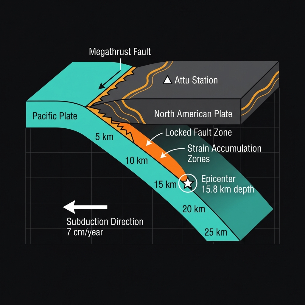
The Rat Islands do not earn their ominous name from geological coincidence. This archipelago straddles the boundary where the Pacific Plate grinds beneath the North American Plate in a process called subduction, creating a megathrust fault capable of generating magnitude 8 earthquakes. The descending plate drags against the overriding crust, building elastic strain over decades until the rock snaps, releasing energy as the seismic waves we feel as earthquakes.
Seismologists classify this as a classic subduction zone environment, the same tectonic setting that produced the devastating magnitude 7.9 Rat Islands earthquake in 2014. That event, centered 186 kilometers from Attu Station, ruptured a portion of the plate boundary and released stress that had accumulated over centuries. While last week’s M5.5 represents a mere fraction of that energy release, it occurs within the same stressed system, suggesting the subduction zone continues its relentless adjustment.
How Does This Event Compare to Recent Activity?
At 15.8 kilometers depth, this earthquake qualifies as relatively shallow, meaning the seismic waves had less time to attenuate before reaching the surface. Such crustal earthquakes often produce sharper, more jolting motion than deeper temblors of equivalent magnitude, though the remote offshore location meant few observers felt the shaking directly. The event stands out not for its individual power, but for its role as the capstone of a week-long swarm that has seen 13 smaller earthquakes pepper the same undersea landscape.
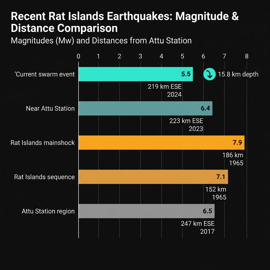
When placed against the region’s historical record, this activity fits a pattern of frequent moderate disturbances punctuated by rare massive ruptures. The Rat Islands have hosted nine magnitude 6 or greater earthquakes since 1991, including a magnitude 6.4 temblor that struck just 49 kilometers from Attu Station earlier this year. The following table illustrates how the current swarm leader compares to significant recent events in this restless corner of the Pacific:
| Earthquake | Magnitude | Depth | Distance from Attu Station | Year |
|---|---|---|---|---|
| Current swarm event | 5.5 | 15.8 km | 219 km ESE | 2026 |
| Near Attu Station | 6.4 | Not reported | 223 km ESE | 2026 |
| Rat Islands mainshock | 7.9 | Not reported | 186 km | 2014 |
| Rat Islands sequence | 7.1 | Not reported | 152 km | 2003 |
| Attu Station region | 6.5 | Not reported | 247 km ESE | 2017 |
What Should Residents Do?
For the sparse population near Attu Station, this swarm demands vigilance without panic. Residents should secure water supplies and emergency provisions against potential aftershocks, which often follow swarm events as the crust adjusts to redistributed stress. While this M5.5 does not indicate an imminent catastrophic megathrust earthquake, the shallow depth means any larger subsequent event could produce locally intense shaking, making it prudent to check structural integrity of shelters and ensure communication equipment remains operational in this remote maritime environment.
What Should We Watch For?
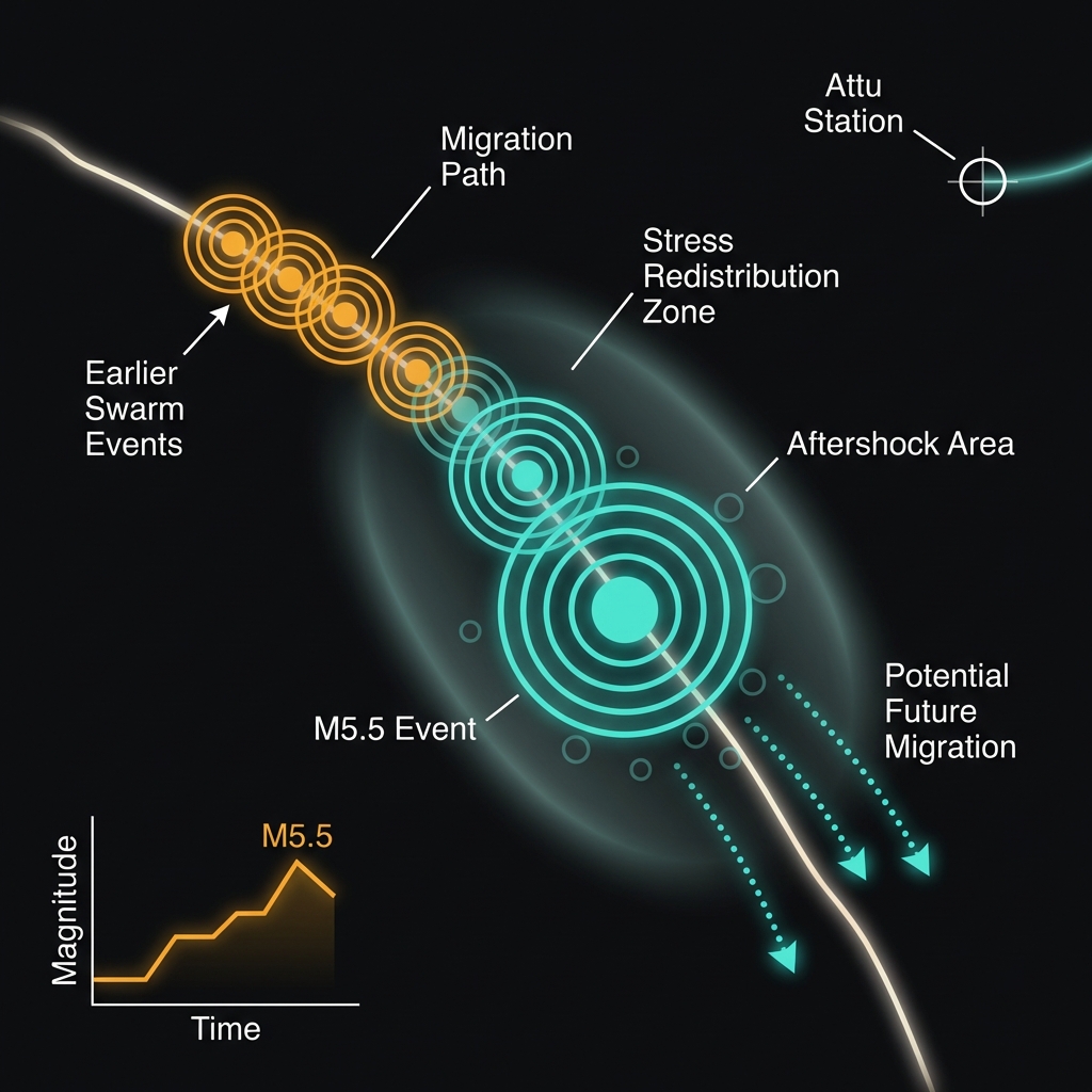
Seismologists will monitor this swarm for signs of escalation, watching whether the earthquakes migrate along the fault or increase in magnitude. Such sequences sometimes represent the early chapters of larger ruptures, though statistically most swarms simply dissipate after releasing localized stress. The USGS will continue tracking aftershock patterns across the Rat Islands subduction zone, providing crucial data on whether this restless week signals business as usual or the opening movements of something more significant in this tectonically charged frontier.
Frequently Asked Questions
How strong was this earthquake?
A magnitude 5.5 earthquake releases approximately 32,000 tons of TNT equivalent energy. At 15.8 kilometers depth, this shallow event likely produced strong local shaking capable of minor structural damage near the epicenter, though the remote offshore location limited exposure to populated areas.
Is there a tsunami risk from this event?
No tsunami warning was issued for this earthquake, and USGS data indicates no destructive ocean wave was generated. The moderate magnitude and specific fault geometry did not displace sufficient water volume to threaten Pacific coastlines.
Why is this area so seismically active?
The Rat Islands sit atop a subduction zone where the Pacific Plate dives beneath North America at approximately 7 centimeters per year. This collision creates immense friction that periodically releases as earthquakes, ranging from frequent moderate swarms to rare magnitude 8+ megathrust events that reshape the archipelago.
Track this event live on the map!
Download GeoShake and get instant earthquake alerts.
Download GeoShake