
At just 8.6 kilometres beneath the surface, the ground convulsed. The shallow depth meant that when the magnitude 5.1 tremor struck near Mount Athos on March 25th, the seismic energy had scant room to dissipate before slamming into the rocky terrain of Greece’s Halkidiki peninsula. According to USGS data, the quake struck at 19:08 UTC, sending ripples of shaking across the Northern Aegean and into Turkish coastal communities nearly 150 kilometres away. It was the largest in a cluster of five tremors that have rattled this contested stretch of sea over the past week, a reminder that the boundary between Europe and Asia remains very much in motion.
Why Is the Northern Aegean So Seismically Restless?
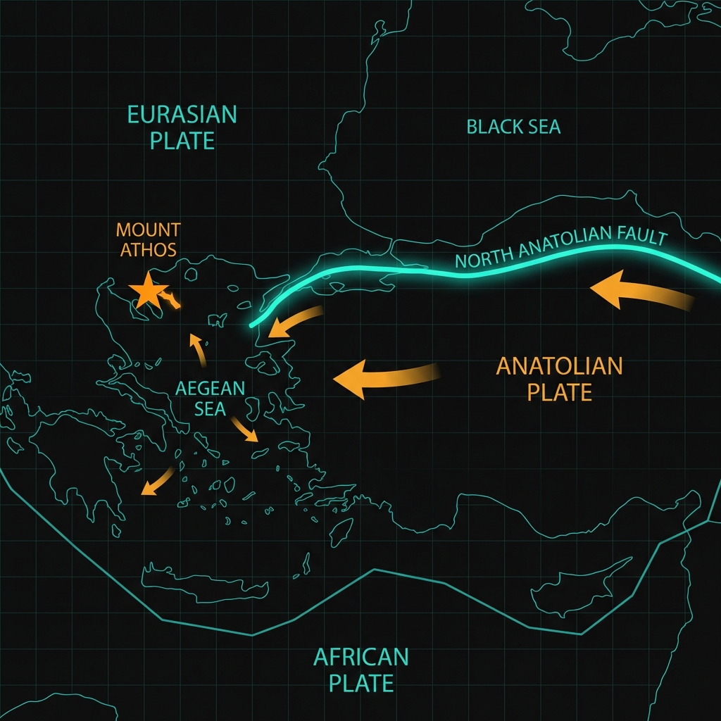
This region sits at a geologic crossroads. To the north, the North Anatolian Fault skirts the southern edge of the sea, carrying Turkey westward toward Greece; to the south, the Aegean Sea is being stretched and thinned as the African plate sinks beneath the Eurasian continent. Seismologists classify this as a zone of complex extension and strike-slip motion, where the earth’s crust is simultaneously being pulled apart and sheared sideways.
Mount Athos itself perches near the western edge of this deformation zone. Over the past four decades, the area has hosted several significant temblors, including a magnitude 6.9 event in 2014 just 117 kilometres away, and a magnitude 6.6 quake in 1995. These historical benchmarks illustrate that while Tuesday’s tremor was moderate, the tectonic machinery here is capable of far greater releases of energy. The current swarm fits this pattern of distributed stress release along a network of faults that spiderweb beneath the Aegean floor.
What Does Eight Kilometres of Depth Mean for Shaking?
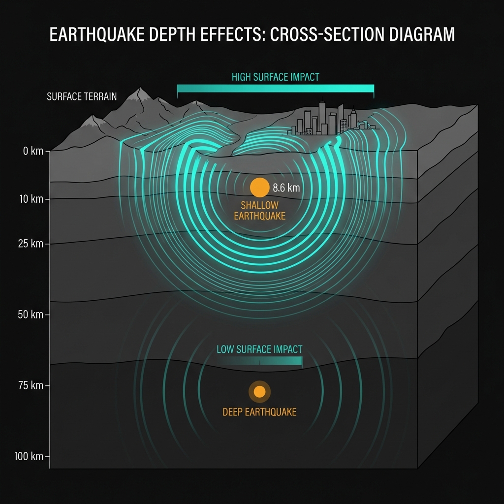
Depth transforms danger. When an earthquake originates just 8.6 kilometres down—barely a third of the way through the Earth’s crust in this region—the seismic waves arrive at the surface with their destructive potential largely intact. Deep earthquakes, by contrast, lose energy to the rock they traverse before ever reaching human structures. Seismologists classify anything above 70 kilometres as shallow, but those under 10 kilometres are particularly efficient at converting underground rupture into surface rattling.
Residents across northern Greece and the Turkish island of Gökçeada likely experienced the shaking as a sharp jolt followed by rolling motion. At magnitude 5.1, the event sits at the threshold where damage becomes possible in poorly constructed buildings, though the region’s strict anti-seismic codes generally mitigate destruction. The tremor was felt as far as Çanakkale, roughly 146 kilometres from the epicentre, demonstrating how shallow origins amplify reach across the water.
| Event | Year | Magnitude | Distance from Epicentre | Tectonic Setting |
|---|---|---|---|---|
| Recent Swarm (largest) | 2026 | 5.1 MW | 0 km | Shallow crustal |
| Kamariótissa quake | 2014 | 6.9 | 117 km | North Anatolian Fault |
| Skýros event | 2001 | 6.5 | 143 km | Aegean extension |
| Týrnavos tremor | 2021 | 6.3 | 169 km | Thessalian strike-slip |
| Gouménissa shaker | 1990 | 6.1 | 162 km | Internal deformation |
This comparison reveals that while the March 25th event was the most significant of the current swarm, it represents a fraction of the energy released by historical neighbours. The 2014 Kamariótissa earthquake, for instance, released roughly 250 times more seismic energy than Tuesday’s tremor, yet both originated from the same broad tectonic processes grinding beneath the Aegean.
What Should We Watch For Next?
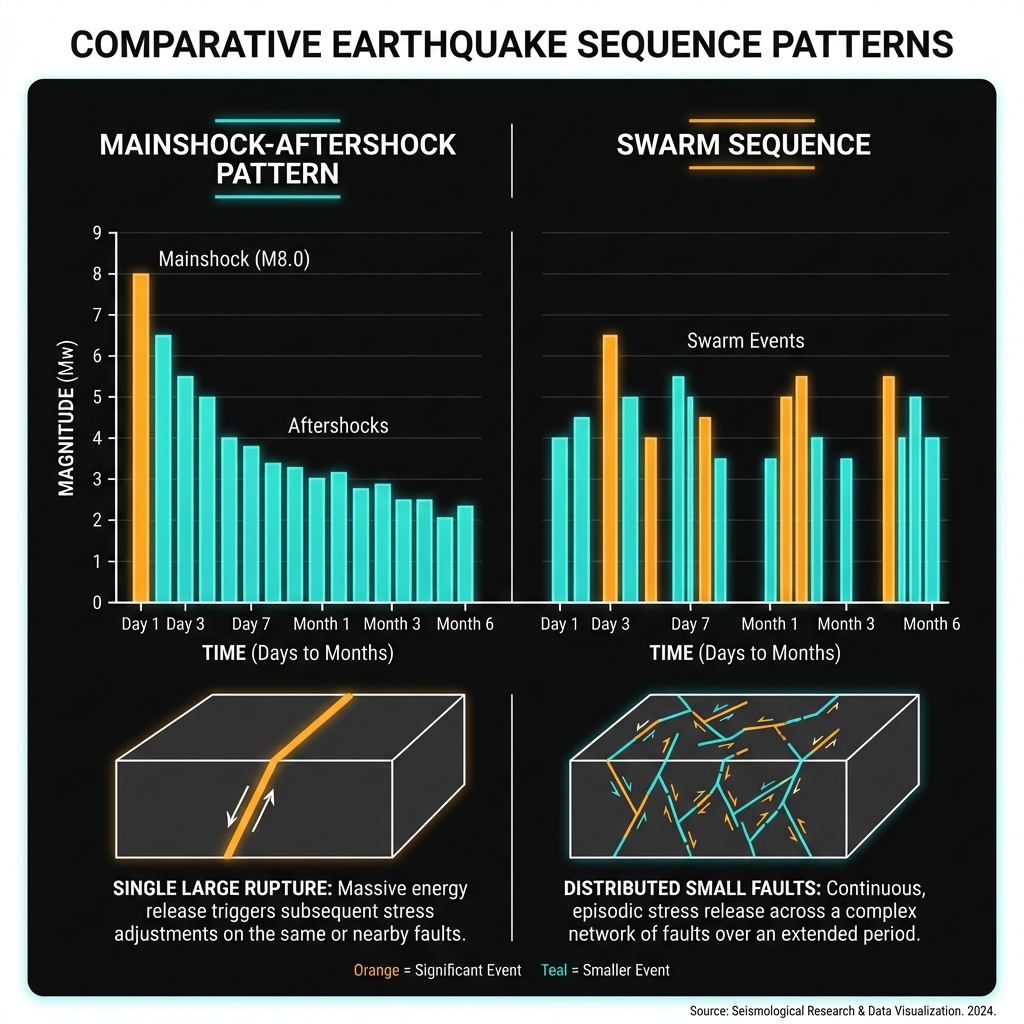
Swarm sequences rarely follow the tidy mainshock-aftershock patterns of larger ruptures. Instead, they represent incremental stress adjustments across multiple small faults. Seismologists will monitor whether Tuesday’s M5.1 marks the culmination of this week’s activity or merely a midpoint.
The absence of a tsunami threat—confirmed by regional monitoring centres—reflects the strike-slip and extensional nature of these faults, which move rocks sideways or apart rather than thrusting them upward to displace water. For now, the Aegean remains seismically chatty, and GeoShake continues to track every whisper beneath the waves.
Frequently Asked Questions
How strong was this earthquake?
The earthquake registered magnitude 5.1 on the moment magnitude scale (Mw), classifying it as a moderate event. While not catastrophic, its shallow depth of 8.6 kilometres meant the shaking felt at the surface was significantly amplified compared to a deeper quake of the same magnitude.
Is there a tsunami risk from this earthquake?
No tsunami warning was issued for this event. The earthquake occurred at shallow depth along faults characterised by sideways or extensional motion rather than vertical thrusting. Without significant vertical seafloor displacement, the water column remains undisturbed, eliminating tsunami generation.
Why is this area so seismically active?
The Northern Aegean sits at the intersection of the North Anatolian Fault and the stretching Aegean Sea. As the African plate subducts beneath Eurasia and Turkey slides westward, the crust here experiences both pulling forces and sideways shearing. This combination creates a complex network of active faults that regularly release energy in earthquakes ranging from minor tremors to magnitude 7 events.
Track this event live on the map!
Download GeoShake and get instant earthquake alerts.
Download GeoShake