
Deep beneath the Pacific Ocean, where the seafloor plunges into the Earth’s mantle at one of the fastest rates on the planet, a magnitude 5.6 earthquake rippled through the subducting Pacific Plate on March 25. Striking just 16 kilometers from the epicenter of the devastating M7.6 quake that shattered the region in 2023, according to USGS data, the tremor occurred at a depth of 198 kilometers, roughly 80 kilometers northwest of Hihifo, Tonga. This event marks the latest pulse in an intense week-long seismic swarm that has produced ten significant earthquakes in seven days, highlighting the relentless tectonic forces operating along the Tonga Trench.
Why Is This Region So Seismically Active?
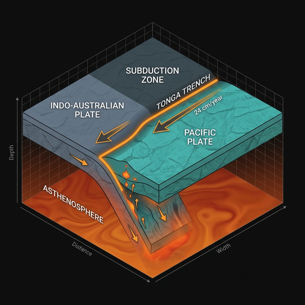
The Tonga Trench represents one of the most violent collision zones on Earth, a scar in the seafloor where the Pacific Plate dives beneath the Indo-Australian Plate at speeds exceeding 24 centimeters per year. This process, known as subduction, creates a geological conveyor belt that transports oceanic crust deep into the mantle, generating immense pressure and friction capable of producing the planet’s most powerful earthquakes. The region bears the scars of this violence: the destructive M7.6 event that struck just kilometers away in 2023, the M7.4 rupture in 1995, and dozens of other major shocks over the past four decades.
Unlike transform faults where plates slide horizontally past each other, subduction zones involve one massive plate forced beneath another, creating a complex three-dimensional stress field. Seismologists classify this environment as capable of producing three distinct earthquake types: shallow crustal events near the surface, massive megathrust earthquakes at the plate interface, and deep intraslab events within the descending slab itself.
What Does 198 Kilometers Underground Mean?
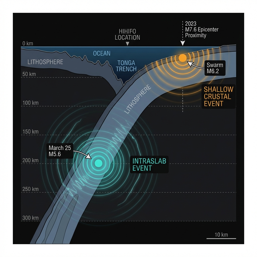
At nearly 200 kilometers depth, this earthquake occurred far below the shallow crustal fractures that typically cause surface destruction, placing it firmly within the subducting Pacific Plate rather than at the boundary with the overlying Indo-Australian Plate. Seismologists classify this as an intermediate-depth intraslab event, resulting from internal stresses and mineralogical changes within the slab as it encounters increasing heat and pressure in the mantle. Deep earthquakes propagate energy efficiently through rigid rock, allowing tremors to be felt hundreds of kilometers away despite causing minimal surface damage compared to shallow shocks of similar magnitude.
The week’s seismic activity illustrates this contrast starkly:
| Event | Magnitude | Depth | Distance from Hihifo | Seismic Characteristics |
|---|---|---|---|---|
| March 25 Event | 5.6 | 198 km | 80 km NW | Deep intraslab; minimal surface damage potential |
| Swarm Maximum (March 2026) | 6.2 | 10 km | 102 km NE | Shallow; higher localized intensity and tsunami risk |
While the shallow M6.2 event posed greater localized tsunami and shaking risks, this deep M5.6 represents the grinding internal deformation of the slab itself. Seismologists note that such events reveal the ongoing brittle failure of the subducting plate as it undergoes phase transitions in the upper mantle. The proximity to the 2023 M7.6 epicenter suggests this may represent continued stress redistribution following that major rupture, or potentially the reactivation of similar structural weaknesses within the descending lithosphere.
What Should We Watch For?
Geoscientists will closely monitor whether this swarm represents a transient stress adjustment within the slab or signals elevated risk for another major plate-boundary earthquake along the trench. Deep intraslab earthquakes rarely trigger tsunamis due to their distance from the seafloor, but clusters like this week’s sequence—spanning from shallow 10-kilometer shocks to this 198-kilometer deep event—demonstrate the full spectrum of rupture styles operating along the Tonga subduction zone. Understanding these deep signals helps researchers distinguish between normal post-seismic relaxation and potential precursors to larger, more destructive shallow earthquakes.
Frequently Asked Questions
How strong was this earthquake?
The earthquake registered magnitude 5.6 on the moment magnitude scale, a moderate event releasing energy roughly equivalent to 1,000 tons of TNT. Because the rupture occurred 198 kilometers beneath the surface, the energy dissipated significantly before reaching inhabited areas, resulting in light to moderate perceived shaking near Hihifo.
Is there a tsunami risk?
No tsunami warning was issued for this event. Deep earthquakes like this M5.6 rarely displace the seafloor sufficiently to generate tsunami waves, unlike shallow ruptures that can vertically offset the ocean bottom.
Why is this area so seismically active?
The Tonga Trench forms part of the Pacific Ring of Fire, where the Pacific Plate subducts beneath the Indo-Australian Plate at one of the fastest convergence rates on Earth. This continuous collision accumulates massive elastic strain that releases periodically as earthquakes, ranging from shallow crustal ruptures to deep slab events like this one.
Track this event live on the map!
Download GeoShake and get instant earthquake alerts.
Download GeoShake