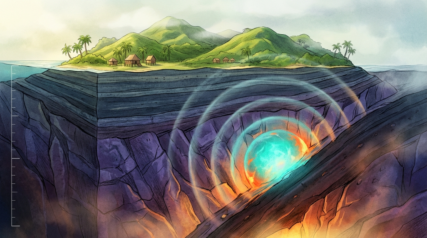
Two hundred three kilometers beneath the rolling hills of southern Mindanao, the Earth flexed. At that depth—roughly the distance between London and Birmingham, or the cruising altitude of a long-haul flight—a magnitude 5.1 earthquake struck early Friday morning, according to USGS data, sending subtle tremors through the Philippines’ second-largest island but posing little threat to the communities above. The event, centered 14 kilometers southeast of Kalbay, offers seismologists a rare window into the interior mechanics of one of the planet’s most complex collision zones, even as it stands in stark contrast to the shallow, devastating temblors that have historically defined the region’s seismic reputation.
Why Is This Region a Seismic Pressure Cooker?
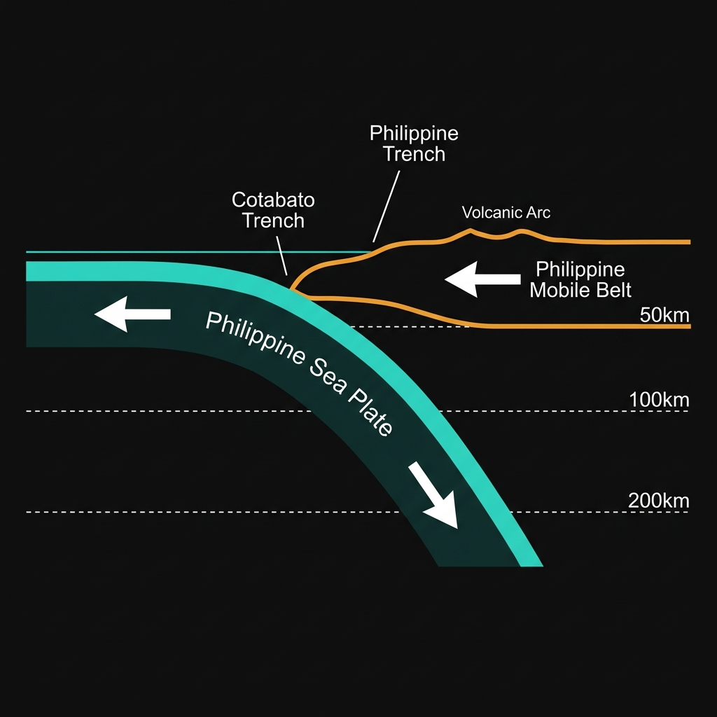
The Philippines sits astride the Pacific Ring of Fire, but that phrase only hints at the tectonic complexity churning beneath the archipelago. Here, the Philippine Sea Plate plunges westward beneath the Philippine Mobile Belt in a process called subduction, creating the Philippine Trench to the east and the Cotabato Trench to the south. This isn’t a gentle descent; it’s a high-stakes geological collision where oceanic crust, formed millions of years ago at mid-ocean ridges, is forced back into Earth’s mantle.
The relentless pressure builds until something gives. Most famously, this happens at the shallow interface between the two plates—depths of 0 to 70 kilometers—where the accumulated strain releases in violent, surface-rupturing earthquakes. The region surrounding Kalbay knows this pattern intimately. In 2002, a magnitude 7.5 earthquake struck Mindanao approximately 156 kilometers away, while a similarly powerful M7.5 event occurred in 2001 near Lukatan. More recently, a M7.1 earthquake rattled the area in 2021, and a M6.7 event struck in 2024 just 100 kilometers from today’s epicenter. These shallow giants carry the destructive potential to generate tsunamis and level cities, a threat that keeps disaster planners vigilant.
What Does Two Hundred Kilometers of Depth Mean for Those on the Surface?
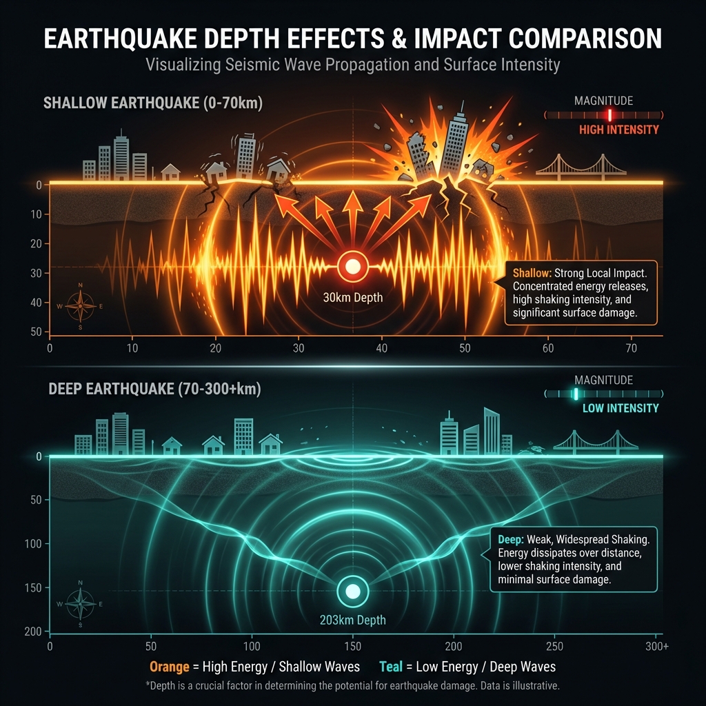
Today’s earthquake occupies a different geological niche entirely. At 203 kilometers depth, this event occurred not at the grinding interface of colliding plates, but within the subducting slab itself—the portion of the Philippine Sea Plate that has already been dragged deep into the mantle. Seismologists classify this as an intraslab earthquake, a phenomenon caused by the internal deformation of the descending plate as it encounters increasing heat and pressure.
The practical difference is stark. While a shallow magnitude 5.1 earthquake can shake the ground with alarming intensity, causing objects to fall and poorly constructed walls to crack, energy released at such extreme depth has vast expanses of rock to traverse before reaching human settlements. By the time the seismic waves arrived at the surface near Kalbay, they had attenuated significantly, spreading outward in a wide radius but with diminished punch. Residents likely experienced a gentle rocking or brief swaying—noticeable, perhaps startling, but a far cry from the violent jolts that accompany shallow events of similar magnitude.
To appreciate the distinction, consider how the region’s seismic history might look different if today’s earthquake had struck closer to the surface:
| Event | Magnitude | Depth (km) | Distance from Kalbay | Impact Profile |
|---|---|---|---|---|
| Today’s earthquake | 5.1 | 203 | 14 km | Deep, widely felt but weak shaking |
| 2024 Sarangani earthquake | 6.7 | ~35 | 100 km | Shallow, strong local shaking |
| 2021 Pondaguitan earthquake | 7.1 | ~50 | 155 km | Shallow, significant regional impact |
| 2002 Mindanao earthquake | 7.5 | ~30 | 156 km | Shallow, destructive potential |
*Depths for historical events estimated based on regional subduction zone characteristics.
The pattern is clear: depth acts as a natural buffer. Yet these deep events serve as crucial diagnostic tools. They illuminate the internal stresses within the subducting slab, helping researchers map the geometry of the plate boundary far below the reach of direct observation. Each intraslab tremor is essentially a flashbulb illuminating the dark, descending machinery of plate tectonics.
What Should We Watch For Now?
In the coming days, seismologists will monitor the region for aftershocks, though deep earthquakes typically produce fewer and weaker aftershocks than their shallow counterparts. The absence of a tsunami warning—standard for deep events where the seafloor doesn’t abruptly shift vertically—will remain in place. However, this gentle reminder of subduction zone activity serves as a prompt for broader vigilance. The Philippine Trench and Cotabato Trench continue to accumulate strain at shallower depths, where the next major earthquake waits not in centuries, but potentially in years or decades. For now, the ground has spoken from the deep, offering scientists data and residents a quiet morning rather than a catastrophe.
Frequently Asked Questions
How strong was this earthquake?
The earthquake registered as magnitude 5.1 on the moment magnitude scale, a moderate event that would typically cause light to moderate shaking if it occurred at shallow depth. However, because it originated 203 kilometers below the surface, the shaking felt at ground level was significantly weaker and more diffuse than the magnitude number alone might suggest.
Is there a tsunami risk from this earthquake?
No. According to USGS data, no tsunami warning was issued for this event. Tsunamis require vertical displacement of the seafloor, which almost exclusively occurs during shallow earthquakes at depths less than approximately 70 kilometers. At 203 kilometers depth, the energy dissipates through the Earth’s crust without disturbing the ocean column above.
Why does this area experience so many earthquakes?
The Philippines sits at the convergence of several tectonic plates, most notably where the Philippine Sea Plate subducts beneath the Philippine Mobile Belt. This continuous collision process generates earthquakes at various depths—from shallow, destructive plate-boundary events to deep intraslab earthquakes like today’s. The region’s history of magnitude 7+ earthquakes, including the 2002 M7.5 and 2001 M7.5 events, reflects this persistent tectonic stress.
Track this event live on the map!
Download GeoShake and get instant earthquake alerts.
Download GeoShake