
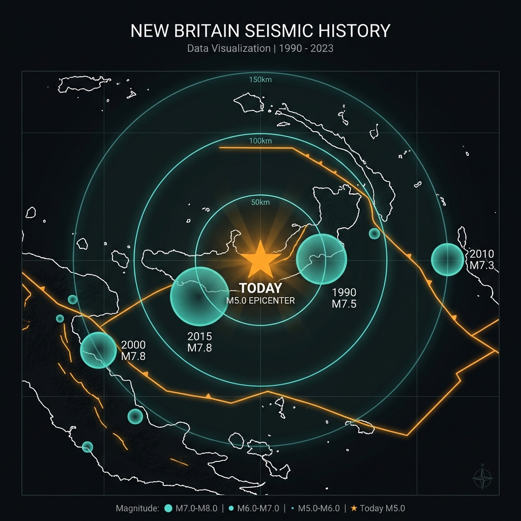
The earth shook just 10 kilometers beneath the surface—shallow enough to amplify shaking violently—only 45 to 50 kilometers from where devastating magnitude 7.8 megathrust earthquakes ruptured in 2000 and 2015. This latest tremor, a magnitude 5.0 event that struck 164 kilometers south of Kokopo, Papua New Guinea, serves as a stark reminder of the region’s unresolved tectonic tensions according to USGS data.
Why Is This Subduction Zone So Dangerous?
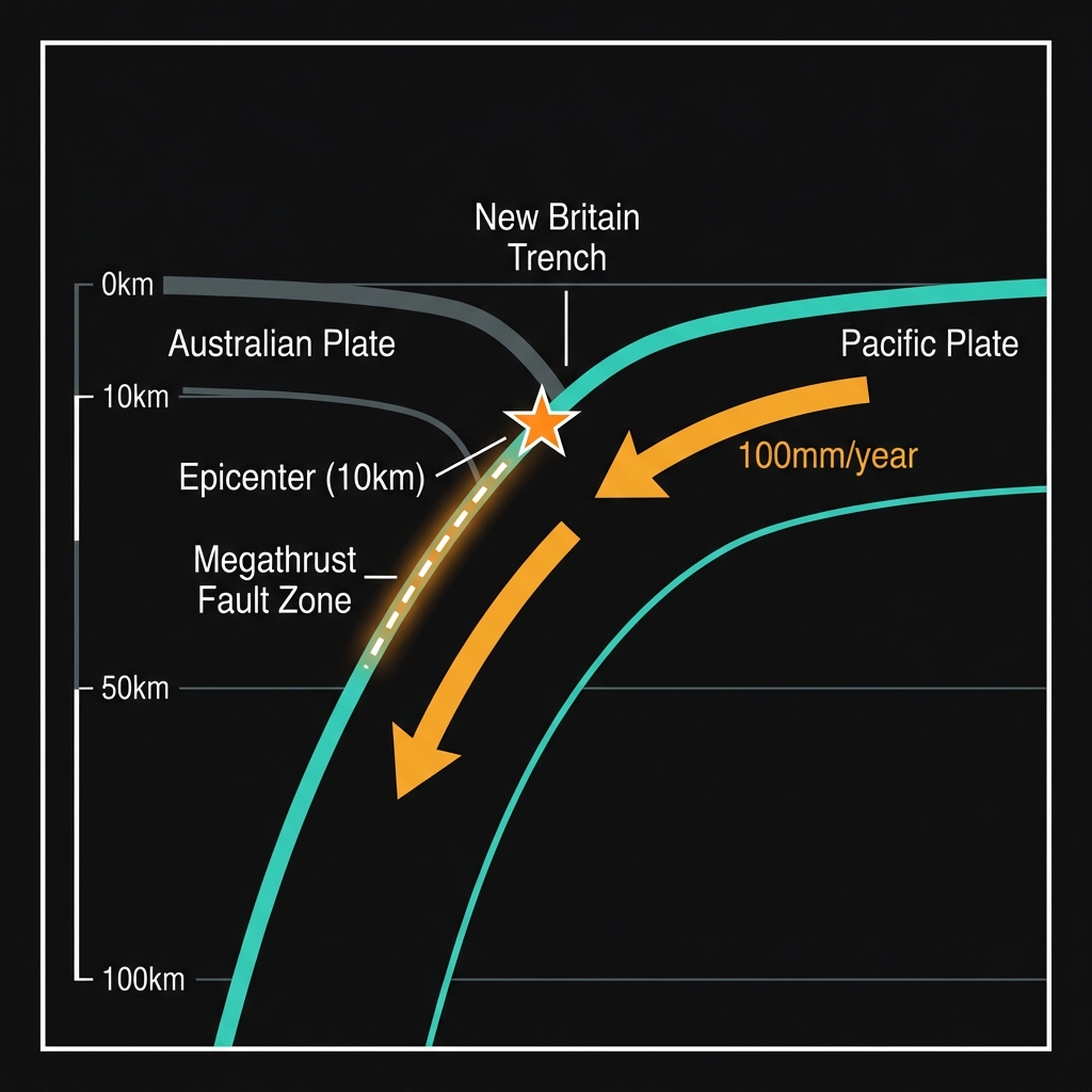
New Britain sits astride one of the most active plate boundaries on Earth. Here, the Pacific Plate dives beneath the Australian Plate in a process called subduction, creating a megathrust fault capable of generating the world’s most powerful earthquakes.
The boundary has produced two magnitude 7.8 events in recent memory—one in 2000 located 49 kilometers from today’s epicenter, and another in 2015 just 45 kilometers away. These were not isolated incidents. Seismological records show a brutal pedigree: magnitude 7.5 events in 1990 and 2015, a magnitude 7.3 in 2010, and multiple magnitude 7.1 tremors in 1999. When plates collide at convergent boundaries like this one, stress accumulates for decades or centuries before releasing catastrophically.
| Event | Year | Magnitude | Distance from Today’s Epicenter | Tectonic Setting |
|---|---|---|---|---|
| New Britain megathrust | 2000 | M7.8 | ~49 km | Megathrust |
| New Britain megathrust | 2015 | M7.5 | ~45 km | Megathrust |
| Today’s event | 2026 | M5.0 | — | Crustal/Interface |
| Kimbe region | 1990 | M7.5 | ~147 km | Megathrust |
| New Britain region | 2010 | M7.3 | ~165 km | Megathrust |
What Does This Depth Mean for Shaking?
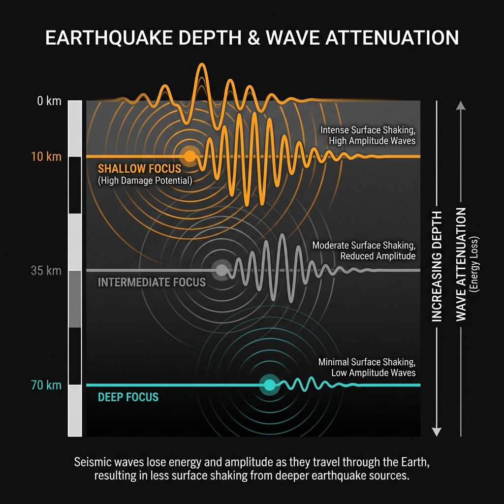
Depth determines destruction. At 10 kilometers, this earthquake occurred in the upper brittle crust, where seismic waves remain intense and unattenuated by distance. Seismologists classify events shallower than 70 kilometers as shallow-focus earthquakes, and those under 20 kilometers pose particular concern for localized damage.
While a magnitude 5.0 releases roughly 32 times less energy than a magnitude 6.0, its shallow depth means the shaking felt at the surface can be surprisingly sharp. Residents within 50 kilometers likely experienced moderate to strong shaking—comparable to a heavy truck striking a building—though the offshore location limited direct structural impacts. The tremor was too small and too deep to trigger a tsunami, according to USGS data.
Is This a Warning Sign?
Single earthquakes rarely predict larger ones, but context matters. This event represents the sole seismic disturbance recorded within 200 kilometers over the past week, suggesting an isolated stress release rather than the beginning of a swarm. However, the proximity to historical megathrust ruptures raises important questions about the subduction zone’s current state of strain.
Seismologists monitor these shallow moderate earthquakes carefully because they sometimes indicate stress redistribution along the main plate interface. The 2000 and 2015 events both occurred on the New Britain Trench, where the Pacific Plate subducts at roughly 100 millimeters per year—one of the fastest convergence rates globally. While today’s magnitude 5.0 did not significantly alter the regional stress field, it highlights that the margin remains loaded and capable of sudden, dramatic failure.
Frequently Asked Questions
How strong was this earthquake?
A magnitude 5.0 earthquake releases energy equivalent to approximately 32,000 tons of TNT. While capable of causing localized damage to poorly constructed structures, especially at shallow depths, this offshore event posed limited risk to coastal communities due to its distance from populated areas.
Is there a tsunami risk from this earthquake?
No tsunami warning was issued for this event. The magnitude 5.0 release was insufficient to displace the water column significantly, and its 10-kilometer depth further reduced any tsunami potential according to USGS data.
Why is this area so seismically active?
The New Britain region sits at the convergence of the Pacific and Australian tectonic plates. As the Pacific Plate subducts beneath New Britain at roughly 10 centimeters per year, strain accumulates along the megathrust fault until it releases in large earthquakes, making this one of the world’s most active seismic zones.
Track this event live on the map!
Download GeoShake and get instant earthquake alerts.
Download GeoShake