
Ten kilometres beneath the craggy coastline of Halkidiki, the Aegean crust gave way with a sharp snap. At 9:08 PM local time on Wednesday, a magnitude 4.9 earthquake struck just east of Ouranoupolis—the sleepy gateway town to the monastic republic of Mount Athos—sending a brief, sharp jolt through the ancient peninsula according to the USGS Earthquake Hazards Program. The shallow depth meant the seismic waves had little time to dissipate before rattling the surface, turning the bedrock into a sounding board that residents felt clearly across the region.
Why Is This Region So Seismically Active?
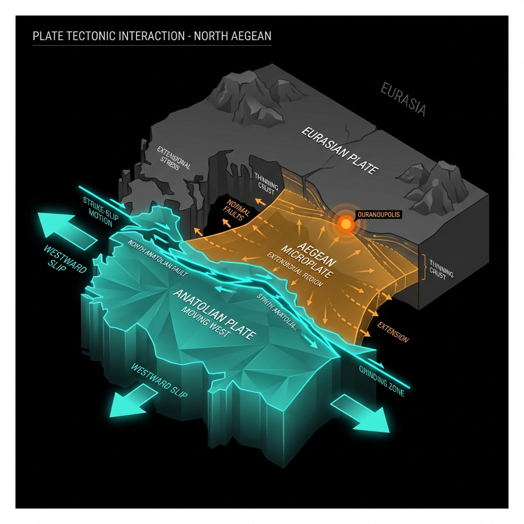
The North Aegean Trough is a geologist’s puzzle box. Here, the Anatolian plate grinds westward against the Eurasian plate, while the Aegean microplate stretches and thins beneath the azure waters like warm toffee pulled apart. This extensional tectonics—where the crust is being actively torn apart—creates a network of strike-slip and normal faults that lace the seafloor between Greece and Turkey.
Ouranoupolis sits near the western margin of this deformation zone. While the great Hellenic Arc to the south hosts the subduction drama of the African plate diving beneath Europe, this northern region dances to a different rhythm. The 2014 M6.9 event near Kamariótissa, just 109 kilometres northeast, ruptured on a similar fault system, releasing roughly 250 times more energy than today’s tremor. Seismologists classify these as shallow crustal earthquakes, meaning they originate in the brittle upper layer of the Earth’s crust where rocks snap rather than flow. Historical records remind us that this area is no stranger to powerful shaking—the 1990 M6.1 Gouménissa earthquake and the 2001 M6.5 Skýros event both occurred within 170 kilometres of today’s epicentre, evidence that the North Aegean stores considerable elastic strain.
What Does Ten Kilometres Mean for Shakers?
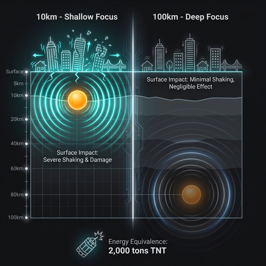
Depth is destiny in seismology. At ten kilometres, this earthquake qualifies as shallow-focus—originating well within the upper crust where the rock is rigid and efficient at transmitting seismic energy. Had the same magnitude occurred at 100 kilometres, the bedrock would have muffled the shaking into a gentle sway felt only by sensitive instruments. Instead, the proximity to the surface meant the ground acceleration reached levels perceptible to humans across a broad radius.
The recent seismic swarm underscores this volatility. Over the past week alone, seven earthquakes have disturbed the North Aegean, including a magnitude 5.1 tremor just 146 kilometres away near Ayion Oros. That event, striking at a similar shallow depth of roughly 8.6 kilometres, produced comparable intensities despite its slightly greater magnitude.
| Event | Magnitude | Depth (km) | Distance from Ouranoupolis | Date |
|---|---|---|---|---|
| Today’s earthquake | 4.9 | 10 | Epicentre | 25 March 2026 |
| Recent Ayion Oros tremor | 5.1 | ~8.6 | ~146 km | ~18 March 2026 |
| 2014 Kamariótissa quake | 6.9 | ~10 | 109 km | 24 May 2014 |
For perspective, a magnitude 4.9 releases energy equivalent to roughly 2,000 tons of TNT—enough to rattle windows and send unsecured objects dancing, but typically insufficient to damage well-constructed buildings. Residents likely experienced Modified Mercalli Intensity IV to V: the sensation of a heavy truck striking the building, or dishes clinking in cabinets. The 2021 M6.3 Týrnavos earthquake, though farther away at 177 kilometres, demonstrated how even deeper events in this region can propagate waves efficiently across the Aegean basin.
What Should We Watch For Now?
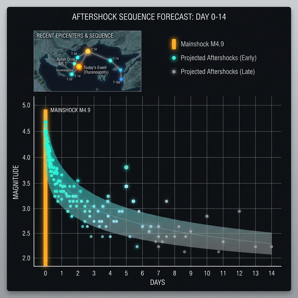
Aftershocks are the earth’s way of settling into a new equilibrium. Following a magnitude 4.9 event, seismologists anticipate a sequence of smaller tremors—typically one magnitude unit lower than the mainshock—over the coming days to weeks. Given that this region has already hosted seven events in the past week, today’s earthquake could represent either the climax of this current swarm or the beginning of a more energetic sequence.
The absence of tsunami warnings reflects the earthquake’s likely strike-slip mechanism and moderate magnitude; vertical seafloor displacement was minimal. However, GeoShake monitoring will continue tracking the fault’s behavior, watching for any migration of hypocenters that might signal stress redistribution toward neighboring segments. The irregular bursts of seismicity here—from the 1990 Gouménissa event to today’s tremor—remind us that the North Aegean remains a dynamic boundary where the map is still being redrawn, one earthquake at a time.
Frequently Asked Questions
How strong was this earthquake?
A magnitude 4.9 earthquake releases approximately 2.3 petajoules of energy, roughly equivalent to 2,000 tons of TNT. At the reported depth of 10 kilometres, this produces light to moderate shaking (Intensity IV-V) capable of rattling dishes and disturbing hanging objects, but rarely causing structural damage to modern buildings.
Is there a tsunami risk from this earthquake?
No tsunami warning has been issued for this event. The combination of moderate magnitude, shallow strike-slip faulting, and the bathymetry of the North Aegean suggests minimal vertical seafloor displacement. Tsunamis typically require larger thrust earthquakes or underwater landslides to displace significant water volume.
Why is this area so seismically active?
The North Aegean sits at the complex intersection of the North Anatolian Fault system and the extending Aegean microplate. As the Anatolian plate moves westward and the Aegean crust stretches north-south, numerous strike-slip and normal faults accumulate strain that releases periodically in earthquakes ranging from minor tremors to magnitude 7 events.
Track this event live on the map!
Download GeoShake and get instant earthquake alerts.
Download GeoShake