Nearly 490 kilometers beneath the shimmering surface of the South Pacific, a magnitude 4.7 earthquake ruptured within the bowels of the Earth on March 24, 2026, a depth so extreme that the energy likely dissipated entirely before reaching the ocean floor above. According to USGS data, the tremor struck south of the Fiji Islands, placing it firmly in the rarefied category of deep-focus earthquakes—events that occur within the subducting Pacific Plate rather than at the brittle crust where most quakes originate.
Why Is This Region a Hotbed of Deep Earthquakes?
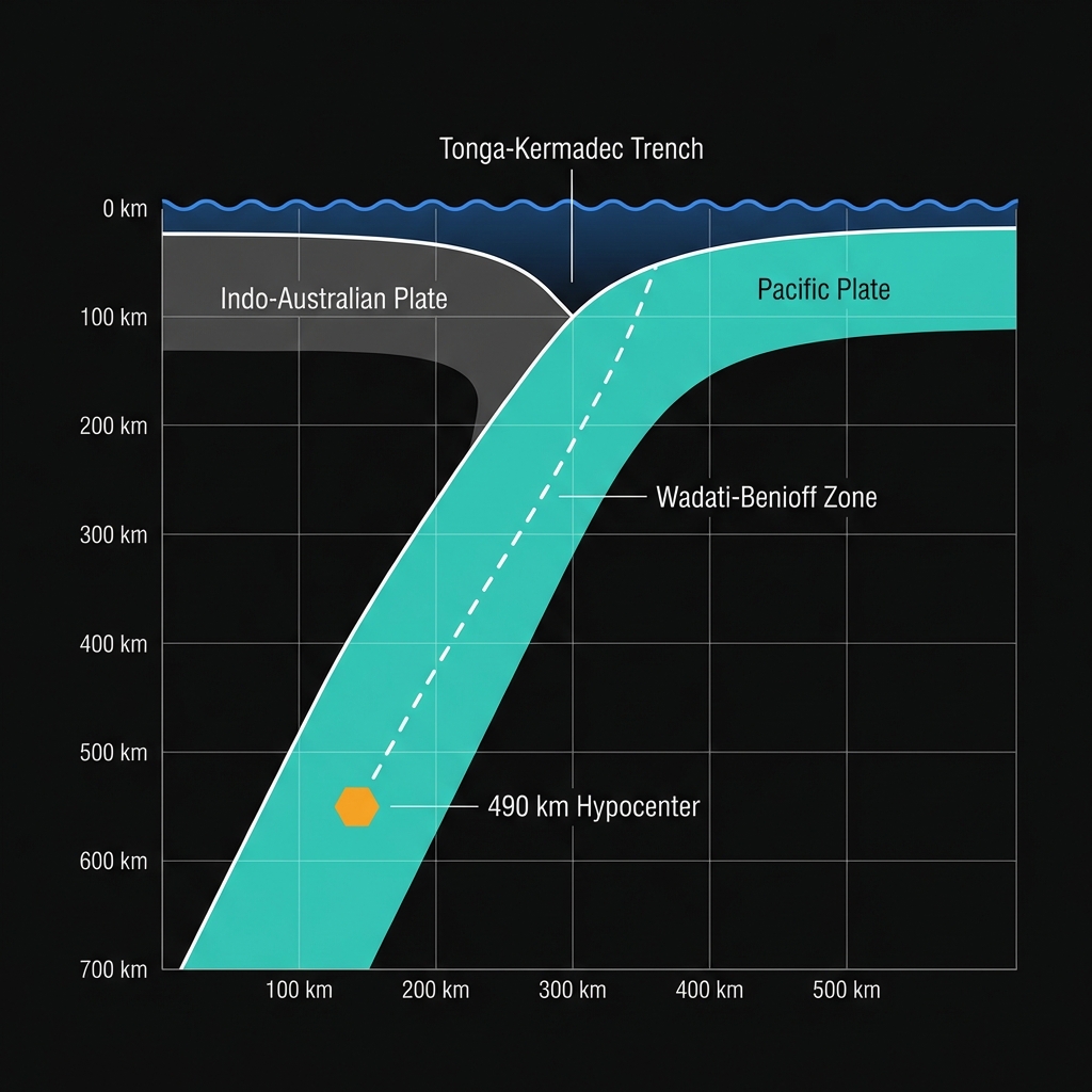
This remote stretch of ocean sits atop one of the planet’s most vigorous subduction zones, where the Pacific Plate dives beneath the Indo-Australian Plate at the Tonga-Kermadec Trench. The collision creates a conveyor belt of seismic activity capable of generating everything from imperceptible deep ruptures to catastrophic shallow megathrust events. Historical records underscore this volatility: in 2002, a magnitude 7.7 earthquake struck 188 kilometers from this location, while a magnitude 6.8 event in 2022 occurred just 39 kilometers away, and as recently as 2025, a magnitude 6.6 temblor rocked the region 160 kilometers distant.
The area’s seismic character reflects the brutal mechanics of plate tectonics. As the Pacific Plate descends into the mantle, it remains cooler and more rigid than the surrounding rock for hundreds of kilometers, allowing it to accumulate stress and fracture even at depths where temperatures and pressures would normally prevent brittle failure. This persistent activity has produced dozens of magnitude 6-plus events since 1993, including significant earthquakes in 2017, 2014, and 2011, each contributing to a pattern of deep-crustal and upper-mantle disruption that defines this boundary.
What Does This Extreme Depth Mean for Surface Impacts?
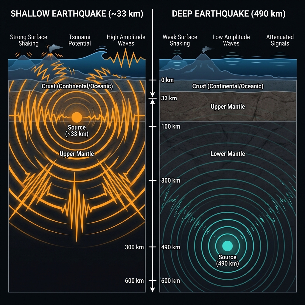
At 490 kilometers down—roughly the horizontal distance between London and Paris—this earthquake occurred in the shadow realm of the lithosphere, far below the reach of surface-dwelling life. Seismologists classify earthquakes deeper than 300 kilometers as “deep-focus,” though this event sits at the extreme end of that spectrum, occurring within the subducting slab itself rather than at the interface between colliding plates. The sheer volume of rock between the hypocenter and the seafloor acts as a shock absorber, dampening the seismic waves so effectively that this magnitude 4.7 event likely registered as nothing more than a faint blip on sensitive seismometers, utterly imperceptible to anyone on nearby islands.
To grasp the significance of this depth, consider how earthquake energy propagates. A magnitude 4.7 event at the surface can rattle dishes and sway buildings, but at nearly 500 kilometers depth, the same energy release dissipates through hundreds of kilometers of viscous mantle rock. The comparison with historical shallow events in this region illustrates this dramatic difference:
| Event | Magnitude | Depth | Distance from Today’s Epicenter | Expected Surface Impact |
|---|---|---|---|---|
| March 24, 2026 | 4.7 | 490 km | — | Imperceptible |
| 2022 South of Fiji | 6.8 | ~33 km* | 39 km | Strong shaking, potential damage |
| 2002 South of Fiji | 7.7 | ~33 km* | 188 km | Widespread destructive potential |
*Typical depth for shallow interface earthquakes in this region.
What Should We Watch For Next?
Deep-focus earthquakes of this nature rarely trigger traditional aftershocks, as the high-pressure environment and ductile nature of the surrounding mantle prevent the cascade of secondary ruptures common in shallow crustal events. Unlike the swarm activity sometimes seen in volcanic regions, this solitary rupture appears to be an isolated stress release rather than the beginning of a sequence, though seismologists will monitor for any stress transfer to shallower sections of the subduction interface. Given the area’s history of major megathrust events capable of generating tsunamis, continued vigilance remains essential even as this particular deep tremor fades from the instruments.
Frequently Asked Questions
How strong was this earthquake?
The earthquake registered as magnitude 4.7 according to USGS data, placing it in the “light” category on the magnitude scale. However, because it occurred at a depth of nearly 490 kilometers, the actual shaking experienced at the surface was negligible to nonexistent, as the extreme depth absorbed most of the seismic energy before it could reach the ocean floor or nearby islands.
Is there a tsunami risk from this event?
No tsunami warning was issued for this earthquake, and none is expected. Tsunamis require vertical displacement of the seafloor, typically caused by shallow underwater earthquakes or submarine landslides. At 490 kilometers depth, the rupture occurred far too deep within the Earth’s mantle to displace ocean water or generate tsunami waves.
Why do earthquakes happen so deep beneath Fiji?
The region sits along the Tonga-Kermadec subduction zone, where the Pacific Plate dives beneath the Indo-Australian Plate at a steep angle. Earthquakes occur within this descending slab of oceanic crust as it bends, cracks, and adjusts to the increasing pressures and temperatures of the mantle, creating a “Wadati-Benioff zone” of seismicity that extends hundreds of kilometers beneath the surface.
Track this event live on the map!
Download GeoShake and get instant earthquake alerts.
Download GeoShake