
Deep Tremor Off New Zealand Offers Window into Hikurangi Subduction Zone
Sixty-six kilometers beneath the rolling swells of the Pacific Ocean, the machinery of plate tectonics ground into motion on Saturday evening, sending a subtle but perceptible jolt through the crust off New Zealand’s North Island. At 5:06 PM UTC on March 22, seismometers recorded a magnitude-4.9 earthquake along the Hikurangi subduction zone—a deep, offshore boundary where the Pacific Plate dives beneath the Australian Plate, creating one of the most geologically active margins on Earth. While the tremor caused no damage and generated no tsunami threat, its position and depth offer a telling glimpse into the forces that have shaped—and occasionally shaken—this region with far greater ferocity, including a magnitude-7.1 event that struck nearby in 2001.
The Hikurangi Margin: Where Plates Collide

The Hikurangi subduction zone represents the southern extent of the Kermadec-Tonga trench system, a 2,500-kilometer scar where the Pacific Plate plunges westward beneath the North Island at rates of approximately 50 millimeters per year. This process, known as subduction, doesn’t proceed smoothly; instead, the descending plate sticks and slips against the overlying crust, accumulating elastic strain that releases periodically as earthquakes. The zone has a long memory: in 2001, a magnitude-7.1 earthquake ruptured approximately 190 kilometers from Saturday’s epicenter, reminding residents of the region’s capacity for significant shaking. The broader Kermadec region has hosted numerous substantial events over the past four decades, including magnitude-6.6 tremors in 1986 and 2011, a magnitude-6.3 shock in 1993, and several other magnitude-6 class events that delineate this active boundary. These historical markers remind us that while Saturday’s event stands alone in the past week’s quiet seismic record, it occurs within a corridor capable of generating substantially more powerful ruptures.
Reading the Shake: Why Depth Matters
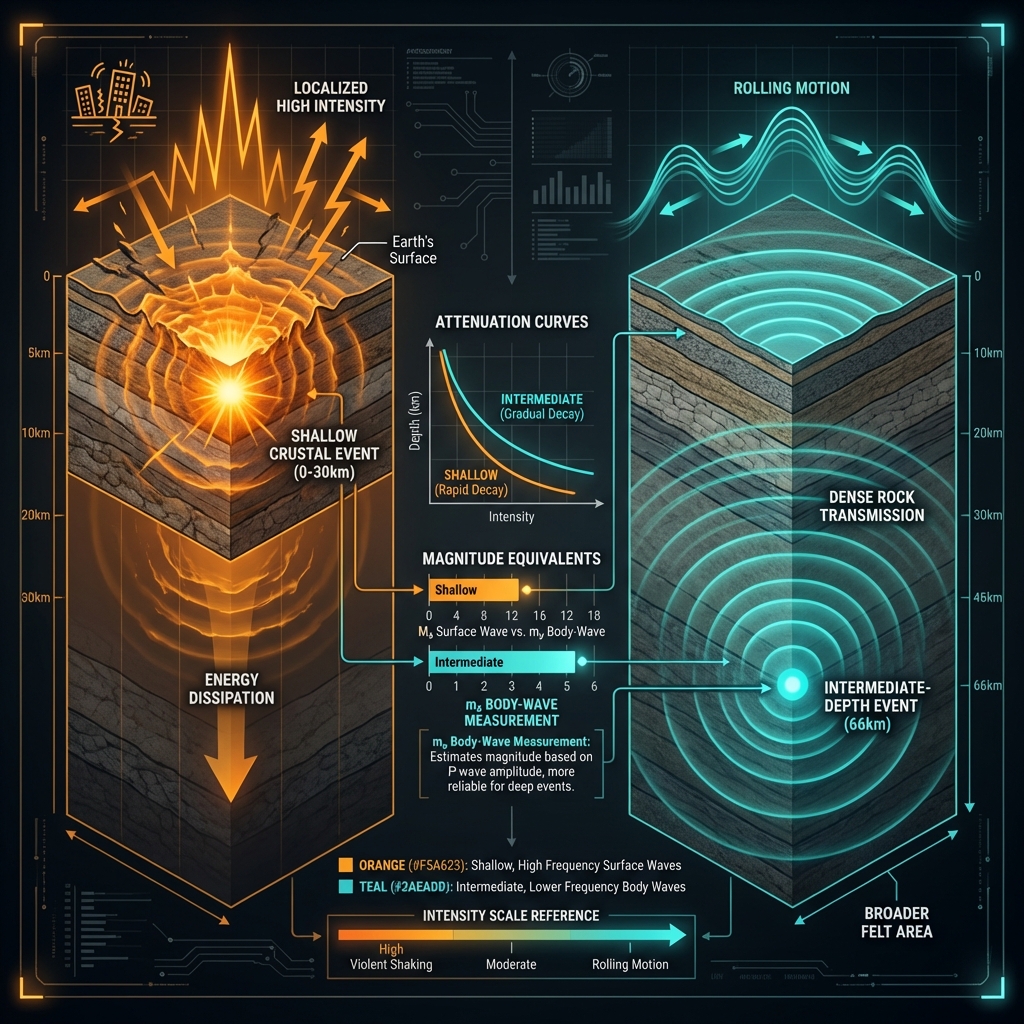
Seismologists classify earthquakes at 66 kilometers depth as “intermediate”—nestled between shallow crustal events (0-70 km) and the deeper quakes that occur as plates descend into the mantle. This depth profile fundamentally changes how energy travels. Unlike shallow earthquakes that concentrate their destructive potential near the epicenter, intermediate-depth events radiate energy upward and outward through denser rock, often producing a rolling motion perceptible across broader distances while diminishing the peak intensity at the surface. A magnitude-4.9 event at this depth typically produces shaking comparable to the passage of a heavy truck or distant thunder—noticeable and briefly alarming, but generally insufficient to damage well-constructed buildings. The offshore location, deep within the descending Pacific Plate, meant the energy had to traverse significant rock volume before reaching North Island communities, further attenuating the impact despite the moderate magnitude.
This type of earthquake tells seismologists a specific story about the mechanics of the subduction interface. The USGS recorded this event using the mb scale (body-wave magnitude), which measures the amplitude of seismic waves traveling through Earth’s interior, suggesting efficient energy transmission through the rigid oceanic plate. Such intermediate-depth events often occur within the downgoing slab itself rather than at the shallow interface between the two plates, indicating internal deformation as the Pacific Plate bends and stretches under the North Island’s weight. While the magnitude-4.9 release relieved only a fraction of the accumulated stress along this margin, it serves as a real-time reminder that the Hikurangi system remains active and loading for future, larger ruptures.
A Continuing Story of Convergence
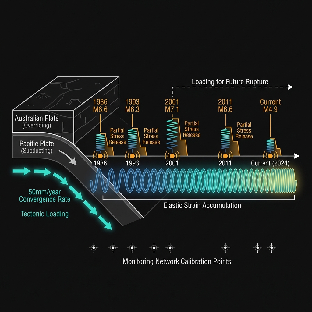
For GeoShake monitoring networks, events like this provide crucial calibration data, helping refine models of how stress distributes through the subduction zone’s complex geometry. The Hikurangi margin continues its slow, relentless convergence, storing energy that will eventually release in earthquakes far exceeding Saturday’s modest reminder. As the Pacific Plate maintains its westward journey at roughly the rate fingernails grow, each tremor—whether a barely perceptible ripple or a ground-shaking jolt—offers another data point in our ongoing effort to understand when the next great release might come. In the meantime, this deep offshore rumble serves as nature’s subtle prompt: the machinery below continues to turn, whether we feel it or not.
Track this event live on the map!
Download GeoShake and get instant earthquake alerts.
Download GeoShake