
Fifteen kilometers. That is the slender margin separating Sunday’s moderate tremor from the exact spot where a devastating magnitude 7.1 earthquake ruptured the seafloor in 1989, killing dozens and leveling homes across the Halmahera Islands. On March 23, 2026, at 11:25 UTC, a M4.6 earthquake struck 140 kilometers west-northwest of Tobelo, Indonesia, rattling the Molucca Sea at a depth of 92 kilometers according to the USGS Earthquake Hazards Program. While the shaking proved too weak to cause damage or panic, its proximity to one of the region’s most destructive historical epicenters serves as a stark reminder that this corner of the Indonesian archipelago operates on geological hair triggers. The seabed here is scarred by repeated massive ruptures, capable of unleashing forces ten times stronger than Sunday’s event without warning.
Why Is This Region So Seismically Active?
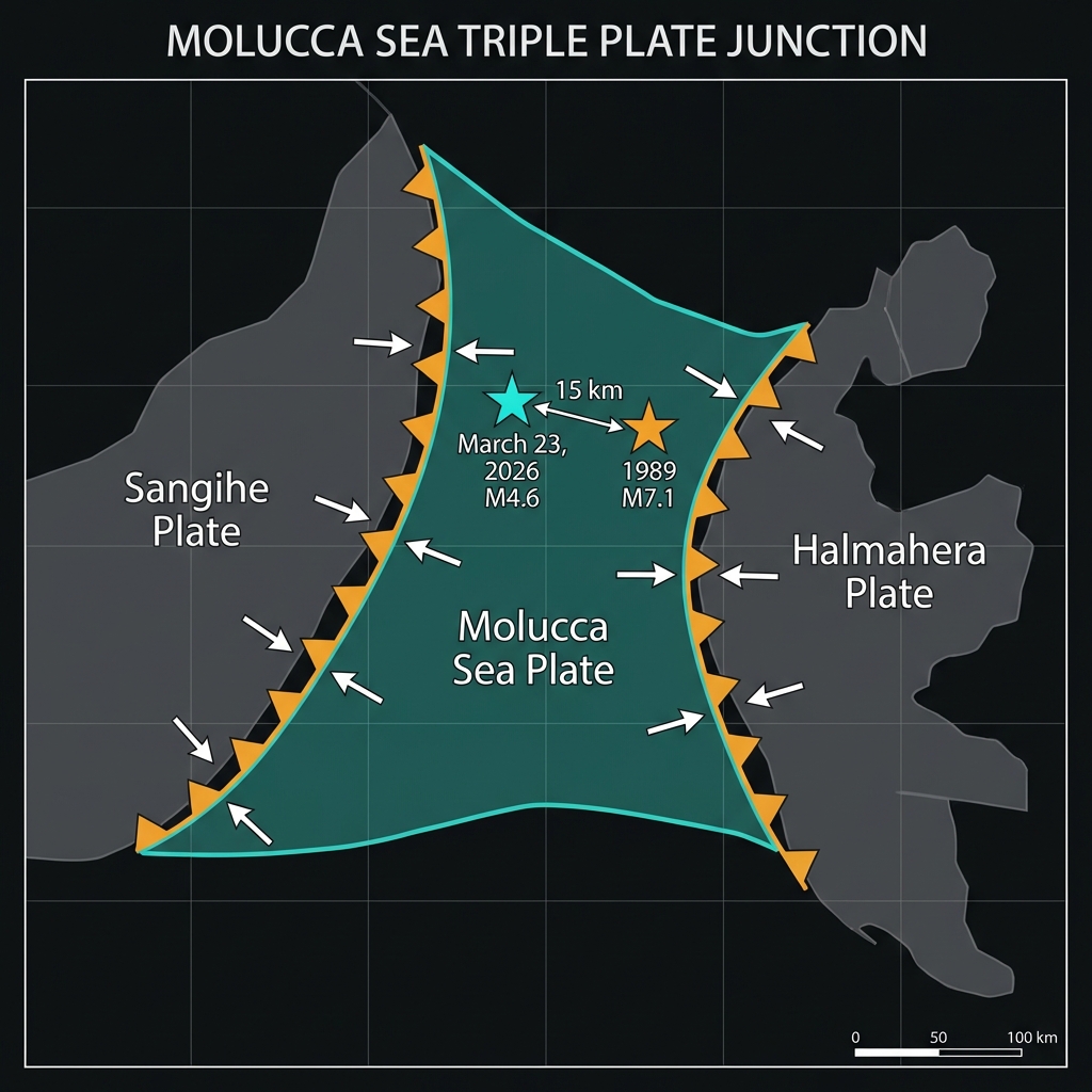
The Molucca Sea sits at a tortuous geological crossroads where three major tectonic plates collide in a relentless process known as subduction. Here, the Molucca Sea Plate is being consumed from both sides—diving beneath the Sangihe Plate to the west and the Halmahera Plate to the east—creating a rare doubly subducting slab that geophysicists consider unique on Earth. This violent convergence builds immense strain in the crust, which releases periodically as earthquakes ranging from imperceptible tremors to catastrophic megaquakes. Seismologists classify this as a subduction zone megathrust environment, the same machinery that generates the world’s most powerful temblors and devastating tsunamis.
Over the past four decades, this specific patch of ocean has produced a disturbing cluster of magnitude 7-plus events. The 1989 M7.1 earthquake struck just 15 kilometers from Sunday’s epicenter, while a 1986 M7.5 rupture occurred 56 kilometers to the northwest. More recently, a 2023 M7.0 event rattled the region from 64 kilometers away, followed by a 2019 M7.1 and a 2014 M7.1, each releasing energy equivalent to millions of tons of TNT. This is not a zone of minor aftershocks but a persistent factory of major seismic hazards.
| Event | Year | Magnitude | Distance from March 23 Epicenter |
|---|---|---|---|
| March 23 Tremor | 2026 | 4.6 | — |
| Tobelo Earthquake | 1989 | 7.1 | 15 km |
| Halmahera Event | 1986 | 7.5 | 56 km |
| Molucca Sea Quake | 2014 | 7.1 | 48 km |
| Tobelo Event | 2023 | 7.0 | 64 km |
| Ternate Event | 2019 | 7.1 | 78 km |
What Does This Depth Mean for the Shaking?
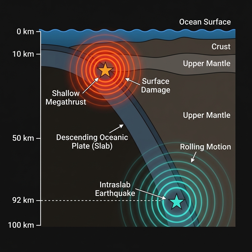
At 92 kilometers below the surface, Sunday’s earthquake originated in the upper mantle, far deeper than the shallow crustal quakes that typically inflict the worst urban damage. Deep earthquakes like this one dissipate their energy across a broader geographical area, creating long-period rolling motions felt over vast distances but with significantly diminished intensity at the surface. Residents of Tobelo likely experienced light shaking—comparable to the rumble of a passing heavy truck or the vibration of a washing machine—while coastal communities as far as Ternate may have noticed only subtle, almost imperceptible vibrations.
Seismologists classify this as an intraslab earthquake, occurring within the cold, brittle interior of the descending oceanic plate rather than at the locked boundary between plates. These events often strike without forewarning and can transfer stress to adjacent sections of the fault, potentially triggering larger shallow earthquakes nearby. The depth also explains the absence of tsunami generation; submarine landslides or seafloor uplift require shallow ruptures, usually less than 50 kilometers deep, to displace significant water volume. Sunday’s event occurred too far beneath the waves to disturb the ocean column meaningfully.
What Should We Watch For Next?
While this M4.6 event represents routine tectonic adjustment rather than a definitive precursor to imminent catastrophe, its location within a known seismic cluster demands scientific vigilance. The region has remained relatively quiet over the past week, with no significant foreshocks detected in the immediate vicinity, yet the historical record demonstrates that these waters can produce magnitude 7-plus earthquakes with intervals as short as a few years. Geoscientists will monitor for any sudden swarm of smaller tremors, subtle changes in sea level, or unusual GPS deformation patterns that might signal accumulating stress on the megathrust interface. For coastal communities from Tobelo to Ternate, Sunday’s tremor offers a moment to verify early warning systems and review evacuation routes—not because disaster is imminent, but because the geological clock here ticks in centuries, and the next great earthquake could arrive at any moment, potentially originating just 15 kilometers from where Sunday’s earth shook.
Frequently Asked Questions
How strong was this earthquake?
The earthquake registered magnitude 4.6 on the body-wave magnitude scale, making it a moderate event capable of producing light shaking felt by people indoors but unlikely to cause structural damage. Because it occurred at a depth of 92 kilometers, the energy had dissipated significantly before reaching the surface, limiting its impact to a broad area of weak perceptibility rather than concentrated destruction.
Is there a tsunami risk from this event?
No tsunami warning was issued for this earthquake, and historical data suggests minimal risk from events of this magnitude and depth. Tsunamis require substantial vertical displacement of the seafloor, which typically only occurs during shallow earthquakes greater than magnitude 7.0; at 92 kilometers depth, this rupture occurred too far beneath the surface to disturb the ocean column meaningfully.
Why is this area so seismically active?
The Molucca Sea sits at the collision point of three tectonic plates—the Molucca Sea Plate, Sangihe Plate, and Halmahera Plate—where double subduction creates one of the most complex and active seismic environments on Earth. This geological setting has produced at least eight magnitude 7-plus earthquakes within 200 kilometers of Tobelo since 1986, including the devastating 1989 M7.1 event that struck just 15 kilometers from Sunday’s epicenter.
Track this event live on the map!
Download GeoShake and get instant earthquake alerts.
Download GeoShake