
The desert floor rippled with unexpected force on April 4, when a shallow magnitude 5.5 earthquake sent shockwaves across Australia’s Red Centre—an event seismologists rank among the most powerful to strike the continent’s interior since a magnitude 6.0 temblor rattled the same remote region nearly a decade ago. Striking just 77 kilometres southwest of Yulara, the tourist gateway to Uluru, the quake’s shallow depth of 10 kilometres amplified the shaking across vast distances of the sparsely populated Northern Territory outback, according to USGS data.
Why Does This Stable Continent Shake?
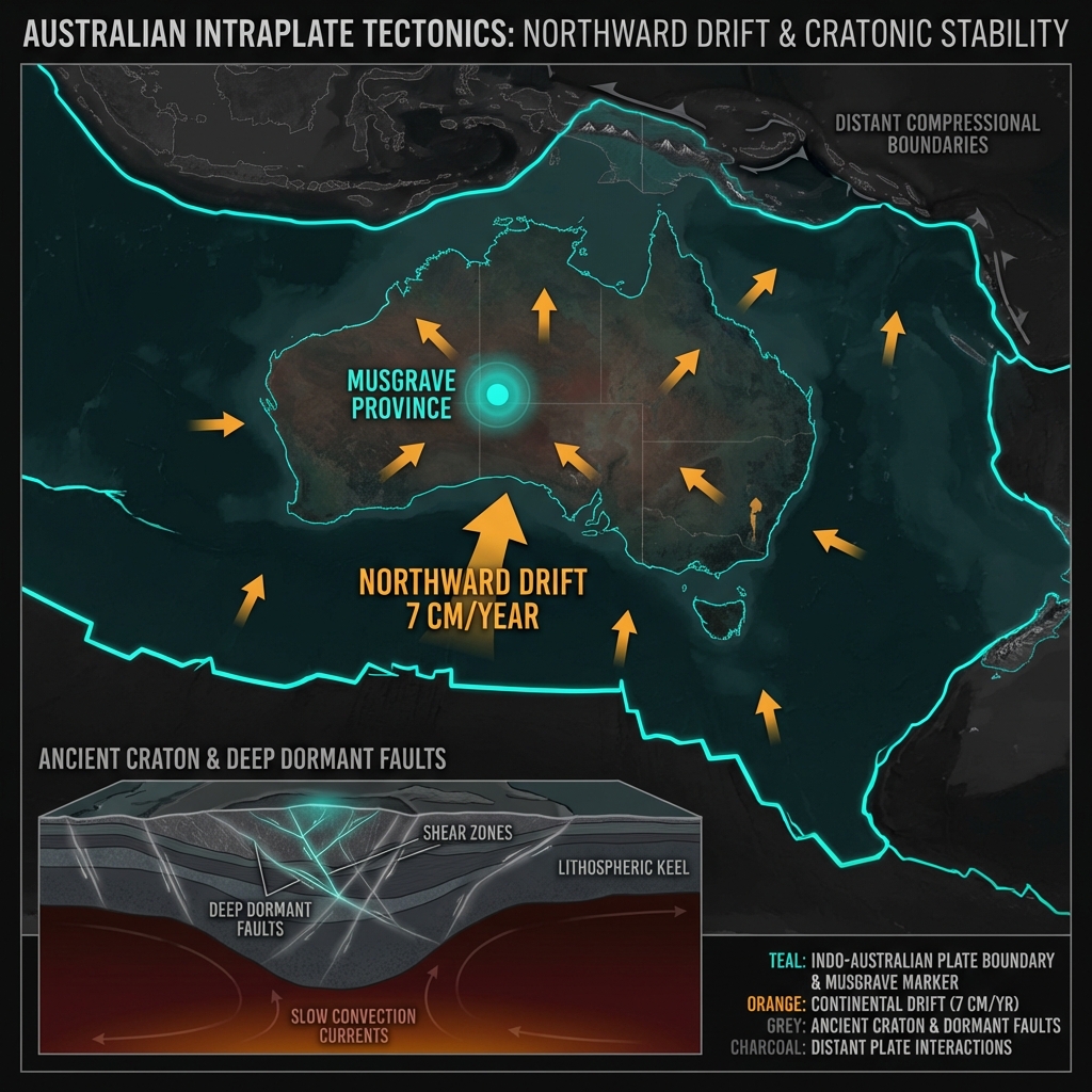
Australia sits squarely in the middle of the Indo-Australian Plate, thousands of kilometres from the nearest tectonic boundary where earthquakes typically spawn. Yet the continent’s ancient craton—the geologically stable core that has survived billions of years of erosion—harbors deep structural weaknesses accumulated over eons of tectonic stress. Seismologists classify this as an intraplate earthquake, a phenomenon where crustal blocks shift along long-dormant faults buried within the plate interior, releasing accumulated elastic strain that has built up as the continent drifts northward at roughly seven centimetres per year.
The Red Centre sits atop the Musgrave Province, a zone of complex ancient geology where Proterozoic mountain belts meet the Amadeus Basin. While this landscape appears immutable to visitors gazing at Uluru’s rust-red monolith, the bedrock conceals fracture zones that occasionally slip. Historical records remind us that this quiet region packs surprising punch: in 2016, a magnitude 6.0 event struck 102 kilometres west-southwest of Yulara, cracking walls at the Uluru resort and reminding residents that stability is relative even in Earth’s most ancient continental hearts.
How Did the Shaking Spread So Far?
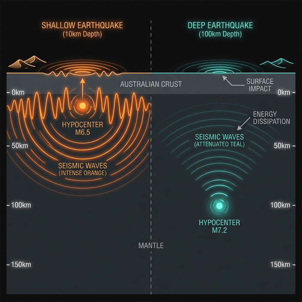
Depth determines devastation. At merely 10 kilometres below the surface—what seismologists call shallow-focus—this earthquake’s energy had little overburden to dissipate through before reaching the desert crust. Deeper quakes lose energy to the viscous mantle; shallow ones transmit the full force of rupture directly to the surface, like a bell struck without padding.
The physics translated to real-world impact across surprising distances. Residents reported feeling the tremor in Alice Springs, more than 300 kilometres northeast, while sensitive seismometers detected the waves travelling outward through the rigid Australian craton for over a thousand kilometres. To understand the difference depth makes, consider that a magnitude 5.5 earthquake at 100 kilometres depth might barely rattle dishes, while this shallow counterpart could knock books from shelves and crack unreinforced masonry.
| Earthquake | Magnitude | Depth | Distance from Yulara | Impact |
|---|---|---|---|---|
| April 2026 Event | 5.5 mww | 10 km | 77 km SSW | Widespread light to moderate shaking |
| May 2016 Event | 6.0 | ~10 km | 102 km WSW | Cracked walls, significant local damage |
This type of earthquake tells us that even stable continental interiors accumulate stress faster than ancient faults can accommodate it gracefully. The 2016 event and this latest tremor suggest the Musgrave Province remains an active locus of strain release, though seismologists caution against interpreting two events as a definitive trend. Australia’s sparse instrumentation makes precise fault mapping challenging, but the similarity in depth and location hints at a possible structural relationship—perhaps the same buried fault system adjusting to regional stresses.
For the scattered pastoralists, Indigenous communities, and tourism operators across the Western Desert, immediate priorities center on structural integrity. Residents should inspect water tanks, gas lines, and dam walls for cracks that might not appear immediately in desert heat, while checking corrugated iron roofing on outstation buildings that may have shifted on foundations. Unlike coastal regions, tsunami risk is nil, but flash flooding following any dam compromise remains a secondary concern in arid zones.
Emergency services recommend checking on isolated neighbors via satellite phone or UHF radio, as cellular coverage remains patchy across the shaking footprint.
What Should We Watch For Next?
Aftershocks typically follow mainshocks in intraplate settings, though the sparse historical record for this specific fault zone offers few precedents. Geoscience Australia and the USGS will deploy portable seismometers to capture any subsequent tremors, which could help map the rupture plane. For now, the region returns to its characteristic silence—deceptively still, yet forever storing the elastic energy that will inevitably announce itself again in another decade, or perhaps another century.
Frequently Asked Questions
How strong was this earthquake?
A magnitude 5.5 on the moment magnitude scale (mww), this earthquake ranks as moderate but significant for the Australian interior. The shallow depth of 10 kilometres meant the shaking intensity reached levels typically associated with larger, deeper events, producing Modified Mercalli Intensity V to VI across the epicentral region—strong enough to cause minor damage to poorly constructed buildings and alarm residents across hundreds of square kilometres.
Is there a tsunami risk from this earthquake?
No. The epicentre lies more than 1,000 kilometres from the nearest coastline, and the magnitude, while significant, is insufficient to generate a tsunami without submarine landslide triggering. Australia’s continental interior earthquakes pose purely terrestrial hazards, primarily structural damage to buildings and secondary risks from damaged infrastructure in remote areas.
Why is central Australia seismically active if it’s not near tectonic plate boundaries?
While Australia sits in the plate’s interior, the continent experiences intraplate seismicity caused by stress transfer from plate boundary forces thousands of kilometres away, combined with local geological weaknesses in ancient crust. The Indo-Australian Plate’s northward collision with Eurasia generates compressional forces that reactivate dormant faults within the stable craton, particularly in zones like the Musgrave Province where ancient mountain-building left deep structural scars.
Track this event live on the map!
Download GeoShake and get instant earthquake alerts.
Download GeoShake