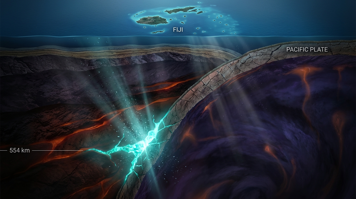
Imagine standing atop the Empire State Building and drilling straight down—not just through bedrock, but through the entire crust, the rigid mantle, and deep into the creeping, pressurized realm where tectonic plates begin to dissolve. Now travel another hundred kilometers deeper still. At 554 kilometers beneath the Pacific Ocean floor—roughly the distance between London and Paris measured vertically—a magnitude 4.7 earthquake struck on March 22, 2026, rattling a section of Earth’s interior that remains less mapped than the surface of Mars. The tremor erupted 211 kilometers east-northeast of Levuka, Fiji, in a zone where the planet’s geological engine operates at pressures capable of crushing carbon into diamond and transforming rock minerals at the atomic level.
The Tectonic Engine Beneath Fiji
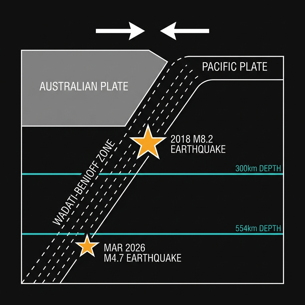
This is the domain of deep-focus earthquakes, events occurring deeper than 300 kilometers within the Wadati-Benioff zone—the sloping seismic plane where the Pacific Plate plunges beneath the Australian Plate in one of Earth’s most vigorous subduction systems. Here, the cold, dense oceanic lithosphere acts like a geological fossil, retaining brittleness long after it has descended into the hot, ductile mantle. While the surface above remained tranquil—no tsunami warning issued, no reports of shaking—the event represents a sudden fracture in that descending slab, a momentary release of strain accumulated as the plate succumbs to the immense forces of mantle convection.
This particular patch of seafloor carries significant historical weight. In August 2018, just 78 kilometers from this recent epicenter, a magnitude 8.2 earthquake ruptured at a nearly identical depth of approximately 563 kilometers, sending seismic waves ricocheting through the planet and temporarily deforming Earth’s surface by centimeters. That event, one of the largest deep earthquakes ever recorded, served as a stark reminder that subduction zones generate their most powerful temblors not at the surface, but within these submerged, descending plates. Since then, the region has maintained a restless cadence: a magnitude 6.5 struck in 2023, while the past week alone has witnessed four seismic events, including a magnitude 5.2 at 501 kilometers depth—suggesting the slab remains dynamically active as it assimilates into the mantle.
Why Depth Changes Everything
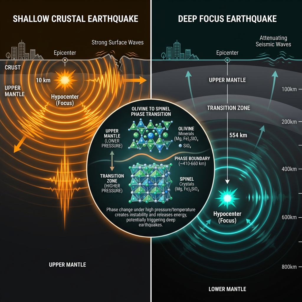
For those keeping score on the surface, a magnitude 4.7 earthquake typically rattles dishes and nerves when it occurs at shallow depths of 10 kilometers. But at 554 kilometers—deeper than the Moho discontinuity that separates crust from mantle, deeper than any human drilling project has penetrated—the physics change dramatically. Seismic energy must travel upward through hundreds of kilometers of dissipating rock, attenuating the shaking until it arrives at the surface as a faint whisper, detectable only by sensitive seismometers. Seismologists classify this as a deep-focus event, distinct from shallow crustal quakes because it originates within the mineral transformation zone where olivine undergoes phase transitions to denser spinel structures, fundamentally altering how rocks break under stress.
The proximity of this event to the 2018 megathrust is scientifically noteworthy. While magnitude 4.7 tremors are orders of magnitude smaller than the 2018 behemoth, their occurrence at similar depths within the same subducting slab suggests ongoing readjustments in the plate’s internal stress field. Unlike shallow subduction earthquakes that often trigger tsunamis by displacing ocean water, these deep events pose little tsunami hazard—the vertical displacement occurs too far below the seafloor to effectively pump the water column. Instead, they serve as geological X-rays, illuminating the geometry and mechanical state of plates that have begun their final descent toward the core-mantle boundary.
The Deepest Rumblings
As the Pacific Plate continues its inexorable dive into Earth’s interior at rates of several centimeters per year, GeoShake monitoring networks remain vigilant, tracking these deep vibrations that reverberate through the planet like bell tones. Each such earthquake—whether a magnitude 4.7 tremor or an historic magnitude 8.2—adds another pixel to our understanding of how rigid surface plates interact with the flowing mantle below. In the silence beneath Fiji, the collision of ancient ocean floor and planetary interior continues, reminding us that even in the most remote depths, the ground is never truly still.
Track this event live on the map!
Download GeoShake and get instant earthquake alerts.
Download GeoShake