Global volcanic monitoring networks tracked 24 distinct eruptive events over the past 24 hours, with the Kamchatka Peninsula’s Shiveluch volcano producing the most significant ash column. According to the Smithsonian Global Volcanism Program and regional observatories including USGS and the Institute of Volcanology and Seismology (IVS) FED RAS, explosive activity generated ash plumes reaching 10,400 meters (34,100 feet) above sea level, triggering immediate aviation advisories across the North Pacific corridor.
Which Volcanoes Generated Aviation Hazards Today?
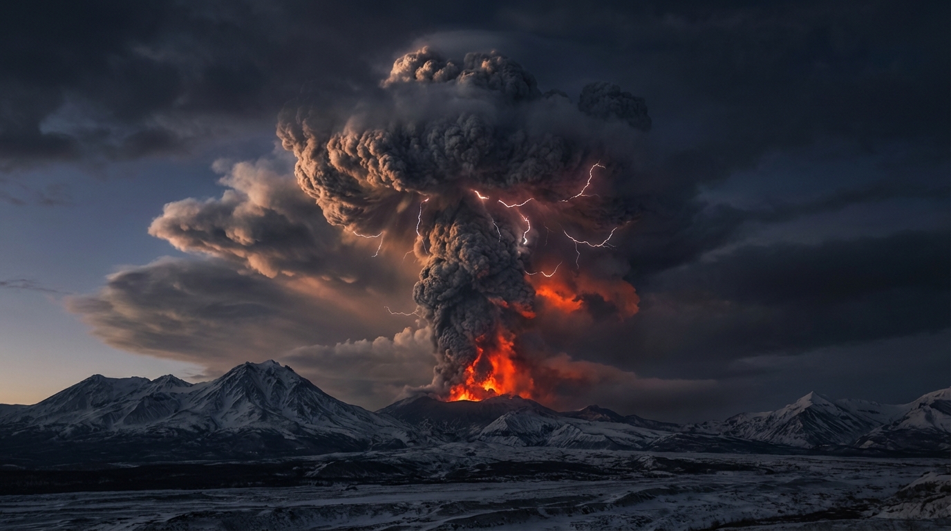
Shiveluch, located on Russia’s Kamchatka Peninsula, dominated the threat landscape with a powerful ash emission recorded at 00:15 UTC on April 3. The eruption propelled volcanic material to flight level 340 (approximately 10,400 meters), well within commercial cruising altitudes for trans-Pacific routes. The Tokyo Volcanic Ash Advisory Center (VAAC) issued immediate warnings for the region, as ash clouds at this altitude can travel hundreds of kilometers downwind and pose catastrophic risks to jet engines.
In Ecuador, Sangay volcano maintained its persistent explosive regime, producing an ash column reaching 7,300 meters (23,900 feet) according to the Instituto Geofísico (IG-EPN). The emission, recorded late on April 2, drifted westward and required coordination between the Washington and Buenos Aires VAACs. Meanwhile, Mexico’s Popocatépetl generated a 6,100-meter (20,000-foot) ash plume that prompted monitoring by CENAPRED and aviation authorities, while Guatemala’s Santiaguito produced both an eruptive event and subsequent ash advisory with plumes reaching 4,300 meters (14,100 feet) according to INSIVUMEH.
How Dangerous Are These Ash Emissions for Aircraft?
Volcanic ash represents a unique aviation hazard because it can melt inside jet engines, causing compressor stall and complete power loss. Today’s Shiveluch emission reached 10.4 kilometers, placing it directly in the path of long-haul flights between North America and Asia. Ash particles at this altitude can remain suspended for days and travel thousands of kilometers from the source volcano, requiring pilots to execute significant route deviations even when the volcano appears distant.
The varying altitudes of today’s emissions create distinct risk profiles. While Shiveluch’s high-altitude plume threatens cruising aircraft, the lower emissions from Santiaguito (4,300m) primarily affect approach and departure corridors at regional airports such as Guatemala City’s La Aurora International. Silica content in these ashes varies by volcano—Shiveluch’s andesitic-dacitic magma typically produces abrasive ash that damages windshields and airframes, whereas the basaltic-andesitic ash from Sangay may have different melting characteristics but remains equally dangerous to turbine engines.
What Other Volcanic Systems Showed Activity?
Beyond the major ash advisories, twelve volcanic systems worldwide exhibited detectable unrest or eruptive behavior. Guatemala’s Fuego volcano maintained its typical Strombolian activity with intermittent explosions and lava flows, while Ecuador’s Reventador produced moderate explosions with ash fall primarily affecting the remote eastern flank. Indonesia’s arc showed significant activity with Dukono (Halmahera), Semeru (East Java), Ibu (Halmahera), and Lewotolo (Lembata) all recording continuous ash emissions or explosive events according to MAGMA Indonesia.
The Philippines’ Mayon volcano remained under close observation by PHIVOLCS, maintaining effusive lava dome growth and occasional explosions. Peru’s Sabancaya, monitored by the Instituto Geofísico del Perú (IGP), continued its persistent degassing and sporadic ash emissions. These concurrent eruptions highlight the ongoing dynamic nature of the Pacific Ring of Fire, where tectonic plate interactions sustain continuous magmatic activity across multiple volcanic arcs.
Active Volcano Summary Table
| Volcano | Location | Event Type | Alert Level |
|---|---|---|---|
| Shiveluch | Kamchatka Peninsula, Russia | Ash Advisory (10,400m) | Orange |
| Sangay | Ecuador | Ash Advisory (7,300m) | Orange |
| Popocatépetl | Mexico | Ash Advisory (6,100m) | Yellow |
| Santiaguito | Guatemala | Eruption/Ash Advisory (4,300m) | Orange |
| Fuego | Guatemala | Strombolian Explosions | Orange |
| Reventador | Ecuador | Explosive Activity | Orange |
| Dukono | Indonesia | Continuous Ash Emissions | Orange |
| Mayon | Philippines | Lava Dome Growth/Effusion | Orange |
| Sabancaya | Peru | Explosive/Degassing | Orange |
| Semeru | Indonesia | Ash Explosions | Orange |
| Ibu | Indonesia | Strombolian Activity | Orange |
| Lewotolo | Indonesia | Strombolian Eruptions | Orange |
Frequently Asked Questions
How high can volcanic ash travel and remain dangerous to aviation?
Volcanic ash can reach the stratosphere, extending well above 10 kilometers (33,000 feet) and remaining suspended for weeks depending on particle size and atmospheric conditions. Ash particles smaller than 2 millimeters pose the greatest threat to jet engines, as they can melt on turbine blades and accumulate, causing engine surge or failure. Even ash concentrations invisible to pilots can cause significant damage, which is why VAACs issue advisories based on satellite detection and ground observations rather than pilot reports alone.
What protective measures should communities take during ash fall events?
Residents should remain indoors with windows and doors closed, use N95 masks or damp cloths to filter breathing air, and avoid driving unless absolutely necessary, as volcanic ash reduces visibility and can clog vehicle air filters. Water supplies should be protected from contamination, and roofs cleared of ash accumulation before the material absorbs rainfall and causes structural collapse. Communities should follow guidance from local geological survey agencies such as USGS, PHIVOLCS, or local civil protection offices regarding evacuation zones.
Which volcanoes currently pose the highest explosive threat?
Based on today’s activity, Shiveluch represents the highest aviation threat due to the extreme altitude of its ash column and the volume of material ejected. Santiaguito and Sangay maintain persistently high explosive indices with frequent ash-producing eruptions that affect populated areas and flight routes. While Popocatépetl’s eruption was less intense today, its proximity to Mexico City (70 kilometers away) and history of Plinian eruptions maintains its classification as a high-threat volcano requiring continuous monitoring by CENAPRED.
Track this event live on the map!
Download GeoShake and get instant earthquake alerts.
Download GeoShake