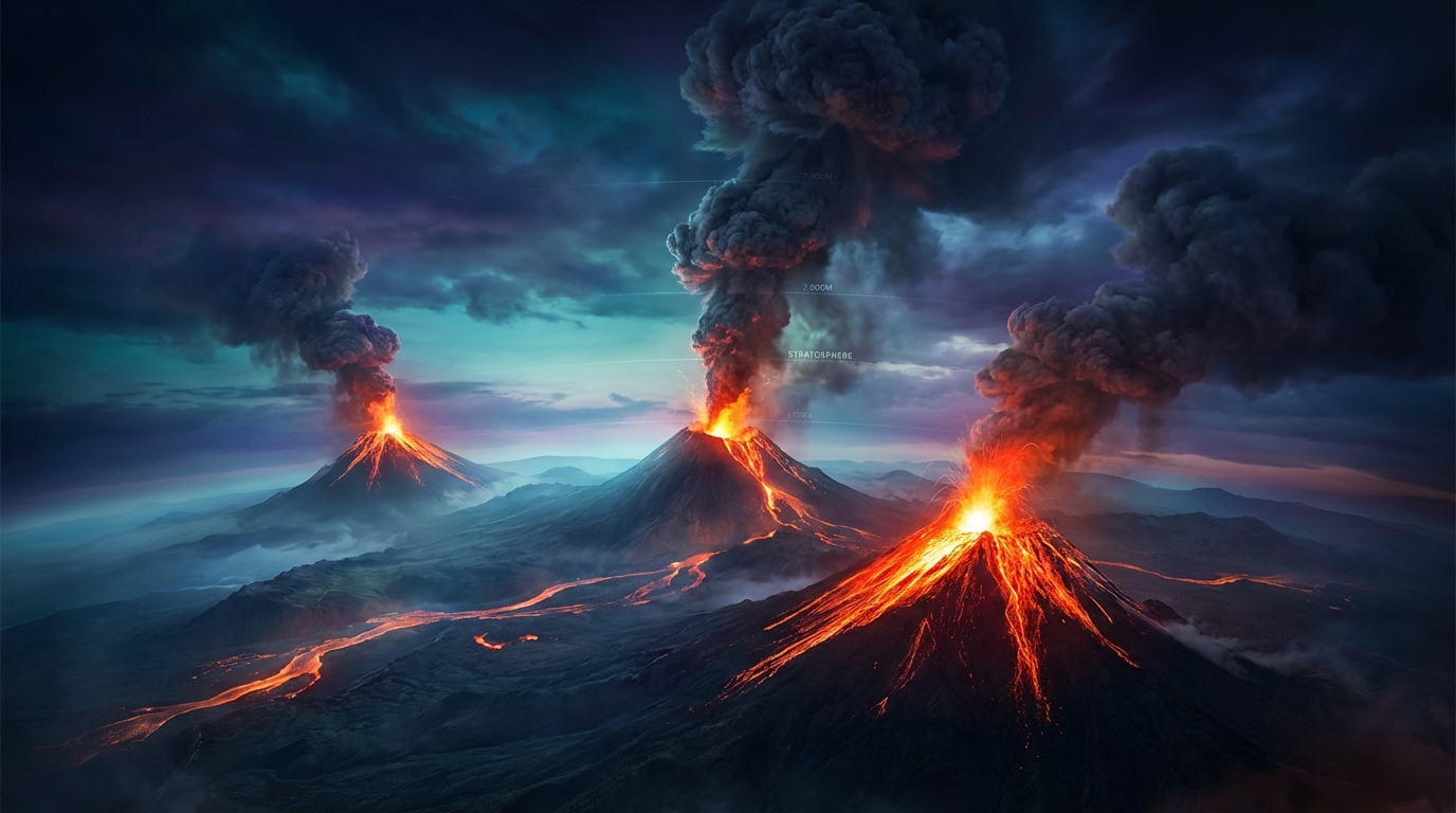
Volcanic activity intensified along the Pacific Ring of Fire during the past 24 hours, with monitoring agencies detecting 18 separate eruptive events according to the Smithsonian Global Volcanism Program and regional Volcanic Ash Advisory Centers (VAACs). Ecuador’s volcanic arc generated significant concern as Sangay and Reventador volcanoes produced substantial ash columns reaching 7,000 meters and 4,900 meters respectively, prompting aviation alerts from VAAC Washington. Concurrently, Indonesia’s archipelago maintained elevated unrest with Semeru and Dukono contributing additional ash advisories, while Guatemala’s Fuego continued its persistent strombolian eruptive episode reported by INSIVUMEH.
Which Volcanoes Erupted Today?
Sangay Volcano in central Ecuador generated the most significant ash emission of the reporting period, producing a plume reaching 7,000 meters (23,000 feet) above sea level according to VAAC Washington reports issued at 22:15 UTC on April 3rd. This stratovolcano, located within the Sangay National Park approximately 40 kilometers from Riobamba, maintains a history of continuous activity characterized by vulcanian explosions and pyroclastic flows.
Reventador, situated in Ecuador’s eastern Andes, produced a separate ash advisory at 03:15 UTC on April 4th, with satellite-confirmed ash columns reaching 4,900 meters (16,000 feet) and drifting west-southwest. The volcano remains one of Ecuador’s most active, frequently producing lava flows and explosive activity from its central crater.
In Indonesia, Semeru Volcano on East Java generated an ash advisory at 19:45 UTC on April 3rd, with emission heights reaching 4,600 meters (15,090 feet) above the summit crater. According to Indonesia’s Center for Volcanology and Geological Hazard Mitigation (PVMBG), this activity represents the ongoing eruptive episode that has persisted since 2021.
Dukono Volcano on Halmahera Island contributed additional ash emissions reaching 3,000 meters (9,840 feet), detected by satellite imagery at 21:45 UTC on April 3rd. This volcano has maintained near-continuous activity since 1933, making it one of Indonesia’s most persistently active systems.
Guatemala’s Fuego Volcano maintained its characteristic strombolian activity with periodic explosions and lava flows, reported by the Instituto Nacional de Sismología, Vulcanología, Meteorología e Hidrología (INSIVUMEH). Additional monitoring detected low-level activity at Mayon in the Philippines, Sakurajima in Japan, Shiveluch in Russia’s Kamchatka Peninsula, Marapi in Sumatra, and Sabancaya in Peru according to the Smithsonian Global Volcanism Program daily updates.
How Dangerous Are the Ash Emissions?
Ash plumes reaching 7,000 meters pose significant hazards to commercial aviation, as these altitudes intersect with cruising flight levels for jet aircraft traversing South American and Southeast Asian corridors. Volcanic ash contains abrasive silicate particles that can melt within jet engines, causing compressor stall and potential engine failure, while also damaging windshields and flight control systems.
Ground-based populations face respiratory hazards when fine ash particles (less than 10 microns in diameter) become airborne, potentially exacerbating asthma and other pulmonary conditions. The dispersed ash from Sangay and Reventador poses particular risk to agricultural sectors in Ecuador’s central highlands, where ashfall can contaminate water supplies and damage crop integrity.
What Should Aviation Operators Know?
Pilots and dispatchers should consult Volcanic Ash Advisory Center (VAAC) Washington for Ecuadorian airspace and VAAC Darwin for Indonesian regions, as both centers issued Significant Meteorological Information (SIGMET) warnings during the 24-hour period. Flight corridors between Quito and Guayaquil may require lateral offsets or altitude changes to avoid the 7,000-meter Sangay plume, while routes crossing East Java necessitate monitoring of Semer’s 4,600-meter emission column.
Aircraft encountering volcanic ash should immediately exit the contaminated area using lateral rather than vertical navigation changes, as ash concentration often remains consistent across altitude bands. Ground stations in Quito, Jakarta, and Singapore reported no immediate airport closures, but sustained activity may trigger temporary airspace restrictions if ash concentrations exceed 4 micrograms per cubic meter.
Which Regions Require Enhanced Monitoring?
Ecuador’s dual volcanic activity demands particular attention from the Observatorio del Volcán Sangay and Instituto Geofísico (IG-EPN), as simultaneous eruptions from Sangay and Reventador strain local monitoring and emergency response capabilities. The 7,000-meter plume from Sangay represents the highest emission event recorded from this volcano in recent weeks, suggesting potential escalation in eruptive intensity.
Indonesia’s PVMBG maintains Level III (SIAGA) alert status for Semeru and Level II (WASPADA) for Dukono, indicating that both volcanoes exhibit clear signs of unrest with potential for further explosive activity. Communities within 8 kilometers of Semeru’s crater rim and 3 kilometers of Dukono should remain prepared for ashfall and potential lahars during rainfall events.
Active Volcanoes Summary Table
| Volcano | Location | Event Type | Alert Level |
|---|---|---|---|
| Sangay | Ecuador | Ash Advisory (7,000m) | Orange |
| Reventador | Ecuador | Ash Advisory (4,900m) | Orange |
| Semeru | Indonesia | Ash Advisory (4,600m) | Level III (SIAGA) |
| Dukono | Indonesia | Ash Advisory (3,000m) | Level II (WASPADA) |
| Fuego | Guatemala | Strombolian Eruption | Orange |
| Mayon | Philippines | Low-level Unrest | Alert Level 1 |
| Sakurajima | Japan | Explosive Eruption | Level 3 |
| Shiveluch | Russia | Dome Growth / Explosions | Orange |
| Marapi | Indonesia | Ash Emission | Level II |
| Sabancaya | Peru | Explosive Activity | Yellow |
Frequently Asked Questions
What immediate health risks does volcanic ash pose to nearby residents?
Volcanic ash presents serious respiratory hazards when inhaled, particularly for children, elderly individuals, and those with pre-existing asthma or cardiovascular conditions. Residents should remain indoors with windows closed during ashfall events, use N95 masks if venturing outside, and avoid driving unless absolutely necessary as ash can reduce visibility and damage vehicle engines. Water supplies may become contaminated, so boiling or filtering water is recommended until authorities confirm potability.
How do scientists determine the height of volcanic ash clouds?
Volcanologists utilize multi-spectral satellite imagery from platforms like Himawari-8, GOES-16, and Meteosat to estimate ash column heights through infrared brightness temperature differentials and shadow analysis. Ground-based radar systems and pilot reports (PIREPs) provide crucial validation data, while atmospheric dispersion models (such as HYSPLIT) track ash movement once initial height parameters are established. These measurements determine aviation alert levels and no-fly zone implementations according to the International Civil Aviation Organization standards.
Why are so many volcanoes active simultaneously along the Pacific Ring of Fire?
The Ring of Fire represents a 40,000-kilometer horseshoe of tectonic plate boundaries where oceanic plates subduct beneath continental plates, creating conditions for magma generation and volcanic arc formation. While individual volcanoes operate on independent magmatic systems, the broad tectonic setting explains the geographic clustering of activity in Ecuador, Indonesia, and Guatemala. Current simultaneous eruptions reflect normal variability in volcanic cycles rather than a connected geological event, according to the Smithsonian Global Volcanism Program.
Track this event live on the map!
Download GeoShake and get instant earthquake alerts.
Download GeoShake