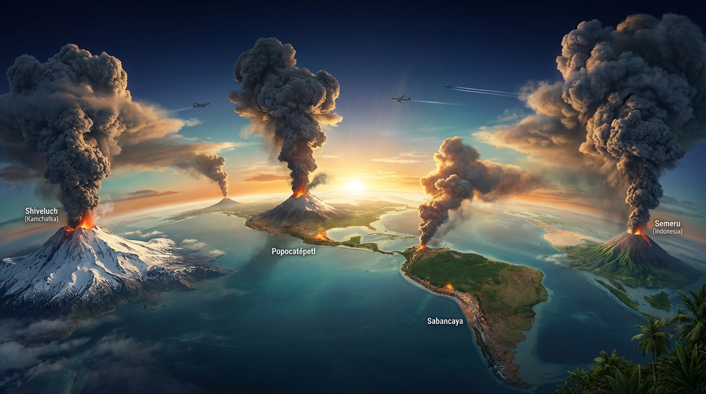
Global volcanic activity remained elevated over the past 24 hours with 29 distinct eruptive events recorded across the Pacific Ring of Fire. According to the Smithsonian Global Volcanism Program, the most significant development came from Russia’s Kamchatka Peninsula, where Shiveluch volcano produced an ash column reaching 8,800 meters (29,000 feet) into the atmosphere. Multiple Latin American and Indonesian volcanoes also generated aviation hazards, with ash advisories issued for peaks in Peru, Mexico, and Java by respective Volcanic Ash Advisory Centers (VAAC).
Which Volcanoes Showed Significant Activity Today?
Shiveluch (Kamchatka, Russia) dominated today’s monitoring reports with a powerful ash advisory issued at 00:15 UTC. The explosive-effusive eruption sent volcanic ash to 8,800 meters (28,900 feet) above sea level, penetrating commercial aviation corridors. According to the Alaska Volcano Observatory and KVERT (Kamchatka Volcanic Eruption Response Team), the volcano maintains an Orange alert level with ongoing dome growth and periodic pyroclastic flows.
Sabancaya (Peru) generated sustained ash emissions reaching 6,700 meters (22,000 feet) according to the Buenos Aires VAAC and IGP (Instituto Geofísico del Perú). The stratovolcano, located 70 kilometers northwest of Arequipa, continues its persistent degassing regime with occasional explosive pulses that scatter ash across the Andean highlands.
Popocatépetl (Mexico) produced continuous emissions with periodic explosions reported at 02:30 UTC by CENAPRED (Centro Nacional de Prevención de Desastres). The ash column reached 6,100 meters (20,000 feet) above sea level, drifting east-southeast toward Puebla state. The volcano remains at Yellow Alert Phase 2, indicating ongoing magma ascent and potential for moderate explosive activity.
Semeru (East Java, Indonesia) registered an ash advisory at 02:15 UTC with plumes reaching 4,600 meters (15,100 feet). PVMBG (Indonesia’s Center for Volcanology and Geological Hazard Mitigation) reported pyroclastic flows extending 2.5 kilometers from the summit crater, driven by partial dome collapse events at the Jonggring Seloko crater.
Santiaguito (Guatemala) completed the day’s significant activity with a discrete explosive eruption detected on April 5 at 21:00 UTC. The Caliente dome produced pyroclastic flows and ash fallout across the Zunil and Quetzaltenango regions, reported by INSIVUMEH (Instituto Nacional de Sismología, Vulcanología, Meteorología e Hidrología).
How High Did the Ash Clouds Rise?
Today’s ash clouds reached critical altitudes for commercial aviation, with Shiveluch’s 8,800-meter column penetrating Flight Level 290 (FL290). At these heights, jet engines face severe abrasion risks from silicate ash particles that melt and coat turbine blades, potentially causing flameout events.
The stratified atmosphere over the Pacific and Americas carried these plumes into distinct flight corridors. Sabancaya’s 6,700-meter ash reached FL220, affecting regional aircraft between Lima and La Paz. Popocatépetl’s 6,100-meter emissions intersected with Mexico City’s busy airspace at FL200. Semeru’s lower 4,600-meter plume primarily threatened domestic Indonesian routes but remained below most international long-haul cruising altitudes.
Meteorological models from the Washington and Darwin VAACs indicate that upper-level winds will transport Shiveluch’s ash eastward across the North Pacific over the next 48 hours. Pilots should anticipate possible diversions along great circle routes between North America and Asia.
What Should Aviation Authorities Know?
Four separate Volcanic Ash Advisory Centers issued warnings today covering distinct airspaces. VAAC Anchorage coordinates the Shiveluch hazard for North Pacific routes, while VAAC Washington monitors Popocatépetl’s impact on Mexican and Central American airspace. VAAC Buenos Aires tracks Sabancaya for South American corridors, and VAAC Darwin manages Semeru’s threat to Indonesian domestic and Australian transit routes.
The International Air Transport Association (IATA) recommends that flight planners treat these advisories as no-fly zones within the reported ash cloud boundaries. Ground-based volcanic lightning detection and satellite-based infrared temperature monitoring confirm that these plumes contain abrasive ash rather than benign steam emissions.
Operators should note that Shiveluch’s ash advisory represents the highest altitude threat currently active globally. The Kamchatkan volcano’s history of sector collapses and dome destruction events creates unpredictable eruption columns that can exceed 10,000 meters without warning.
Active Volcano Summary
| Volcano | Location | Event Type | Alert Level |
|---|---|---|---|
| Shiveluch | Russia (Kamchatka) | Ash Advisory (8,800m) | Orange |
| Sabancaya | Peru (Arequipa) | Ash Advisory (6,700m) | Yellow |
| Popocatépetl | Mexico (Central) | Ash Advisory (6,100m) | Yellow Phase 2 |
| Semeru | Indonesia (Java) | Ash Advisory (4,600m) | Orange |
| Santiaguito | Guatemala | Explosive Eruption | Orange |
| Fuego | Guatemala | Strombolian Activity | Orange |
| Reventador | Ecuador | Discrete Explosions | Orange |
| Mayon | Philippines | Gentle Effusion | – |
| Canlaon | Philippines | Degassing | – |
| Dukono | Indonesia (Halmahera) | Continuous Ash | – |
| Ibu | Indonesia (Halmahera) | Minor Eruption | – |
| Sangay | Ecuador | Ash Emissions | – |
| Marapi | Indonesia (Sumatra) | Explosions | – |
| Aoba | Vanuatu | Minor Activity | – |
Frequently Asked Questions
What does an ash height of 8,800 meters mean for commercial flights?
An ash column reaching 8,800 meters (29,000 feet) penetrates the typical cruising altitude of commercial jetliners, which normally operate between FL300 (9,144m) and FL410 (12,497m). Volcanic ash contains silicate particles that melt inside jet engines and adhere to turbine blades, causing engine surge, flameout, or permanent damage. VAAC advisories at these altitudes trigger airspace closures or mandatory rerouting that can add thousands of kilometers to flight paths.
How do scientists determine volcano alert levels like Orange or Yellow?
Volcanologists assess alert levels using real-time monitoring of seismic tremor frequency, ground deformation patterns measured by GPS and InSAR satellite data, gas emission rates (primarily sulfur dioxide), and visual observations of eruptive activity. An Orange alert indicates heightened unrest with increased likelihood of hazardous eruption, while Yellow signifies elevated activity above background levels without immediate explosive threat. These designations follow standardized protocols established by the International Association of Volcanology and Chemistry of the Earth’s Interior (IAVCEI) and local geological survey agencies.
Is it safe to travel to regions near these active volcanoes?
Travel safety depends on maintaining distance from active craters and respecting exclusion zones established by local civil protection agencies. For Popocatépetl, Mexican authorities maintain a 12-kilometer restricted radius, while Indonesia recommends 5-kilometer exclusion for Semeru and 8 kilometers for Dukono. Even outside these zones, ashfall can cause respiratory distress, disrupt ground transportation, and contaminate water supplies. Travelers should consult their national geological service and the Smithsonian GVP Weekly Volcanic Activity Report before visiting volcanic regions.
Track this event live on the map!
Download GeoShake and get instant earthquake alerts.
Download GeoShake