Volcanic Unrest Intensifies Across Pacific Rim: 26 Events Recorded in 24 Hours
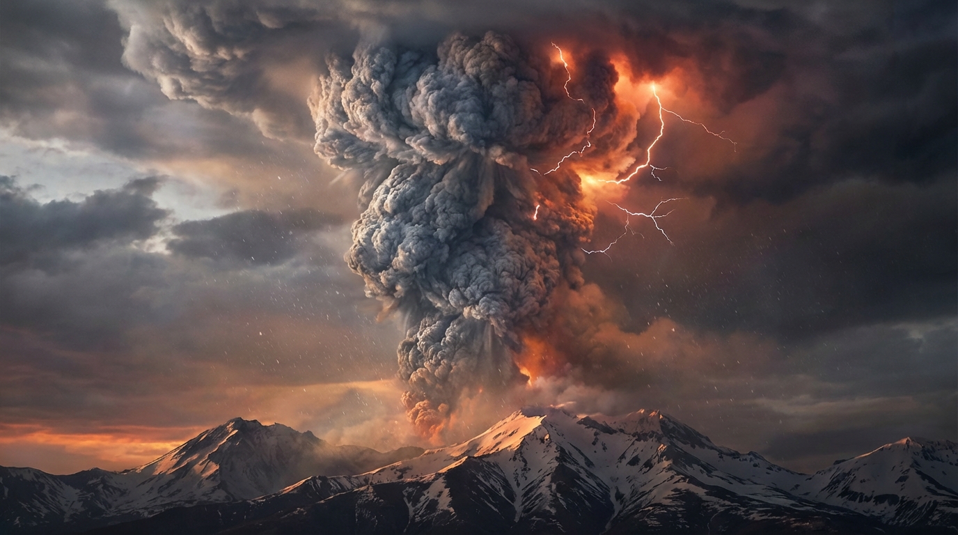
Volcanic activity intensified across the Pacific Ring of Fire during the past 24 hours, with monitoring agencies recording 26 discrete eruptive events from 14 distinct volcanic systems. According to the Smithsonian Global Volcanism Program and regional observatories, the most significant activity occurred at Shiveluch in Russia’s Kamchatka Peninsula, where explosive eruptions sent ash plumes reaching 9,100 meters (29,900 feet) into the atmosphere. Additional high-altitude ash emissions were reported from Sabancaya in Peru and Sangay in Ecuador, prompting aviation advisories and raising alert levels across multiple volcanic arcs.
Which Volcanoes Generated Critical Ash Advisories Today?
Five volcanic systems produced ash plumes requiring immediate aviation alerts according to Volcanic Ash Advisory Centers (VAAC). Shiveluch, located on the Kamchatka Peninsula in eastern Russia, produced the highest plume of the reporting period at approximately 9,100 meters (29,900 feet) above sea level on April 7. This stratovolcano, known for its highly explosive dome-collapse events, created an ash cloud extending northeastward toward the Bering Sea, with the potential for pyroclastic flows and lahars affecting the Klyuchevskaya group of volcanoes.
In South America, Sabancaya in southern Peru generated continuous ash emissions reaching 6,700 meters (22,000 feet) early on April 8. The Peruvian Geophysical Institute (IGP) reported sustained Vulcanian explosive activity with ash dispersing toward the southeast, affecting regional air corridors between Lima and Cusco. Meanwhile, Sangay in Ecuador produced ash columns up to 6,400 meters (21,000 feet) according to the Ecuadorian Institute of Geophysics, with pyroclastic flows potentially affecting the volcano’s eastern flank and ash fall reported in the Morona Santiago province.
Indonesia’s Semeru, on the island of Java, maintained its pattern of frequent Strombolian explosions, sending ash to 4,600 meters (15,100 feet) on April 8. The Center for Volcanology and Geological Hazard Mitigation (PVMBG) noted that the eruption produced a gray ash column drifting southwest, impacting agricultural areas in the Lumajang district and generating volcanic earthquakes with amplitudes up to 22 millimeters. Guatemala’s Fuego volcano also entered an active eruptive phase, producing lava flows and ash emissions, though specific ash height data was not immediately available from INSIVUMEH in the preliminary reports compiled by the Smithsonian Global Volcanism Program.
How Are These Eruptions Affecting Aviation Safety?
The ash plumes reported today intersect critical commercial flight levels, particularly the Shiveluch emission reaching flight level 300 (FL300) and above. According to the Tokyo and Anchorage VAACs, volcanic ash advisories remain active for airspace over the North Pacific, potentially affecting transpacific routes between North America and Asia. Aircraft encountering these ash concentrations face severe risks including engine flameout, loss of thrust, and pitot tube failures due to the abrasive silicate content of the volcanic glass.
Pilots operating near Sabancaya and Sangay must navigate reduced visibility conditions and potential airport closures in Arequipa, Quito, and Guayaquil. The 6,700-meter plume from Sabancaya sits directly within the cruising altitude of commercial jetliners, necessitating flight level adjustments of 2,000 to 4,000 feet below or above the ash layer to prevent turbine blade coating and engine surge. Aviation authorities recommend continuous monitoring of SIGMETs (Significant Meteorological Information) for the Lima and Guayaquil flight information regions, with temporary flight restrictions possible if ash concentrations exceed 4 micrograms per cubic meter.
What Other Volcanic Systems Showed Significant Activity?
Beyond the primary ash advisories, monitoring networks detected significant unrest at nine additional volcanic complexes across the Pacific basin. Dukono in Indonesia’s Halmahera region maintained continuous low-level ash emissions with plumes reaching 2,100 meters, while Reventador in Ecuador produced incandescent material and block avalanches visible from seismic monitoring stations. The Philippine Institute of Volcanology and Seismology (PHIVOLCS) reported sustained unrest at both Mayon and Canlaon, with the former showing lava dome growth and increased sulfur dioxide flux, and the latter recording shallow volcanic earthquakes suggesting hydrothermal pressure changes.
White Island (Whakaari) in New Zealand exhibited minor hydrothermal activity and elevated gas output according to GNS Science, though no eruptive ejecta was detected. Japan’s Sakurajima produced small explosive events with ash fall restricted to the immediate vicinity of Kagoshima Bay, triggering entry restrictions within a 2-kilometer radius of the Showa crater. Ibu, another Indonesian volcano located on Halmahera Island, continued its ongoing eruption with lava flows extending 800 meters from the summit and intermittent ash clouds reaching 3,000 meters, forcing the evacuation of several villages in the surrounding districts.
| Volcano | Location | Event Type | Alert Level |
|---|---|---|---|
| Shiveluch | Kamchatka Peninsula, Russia | Ash Advisory | Orange |
| Sabancaya | Peru | Ash Advisory | Orange |
| Sangay | Ecuador | Ash Advisory | Orange |
| Semeru | Indonesia | Ash Advisory | Orange |
| Fuego | Guatemala | Eruption | Red |
| Dukono | Indonesia | Continuous Ash | Yellow |
| Reventador | Ecuador | Eruption | Orange |
| Mayon | Philippines | Lava Dome Growth | Level 2 |
| White Island | New Zealand | Hydrothermal | Green |
| Ibu | Indonesia | Eruption | Orange |
| Canlaon | Philippines | Volcanic Earthquakes | Level 1 |
| Sakurajima | Japan | Explosive Eruption | Level 3 |
Frequently Asked Questions
How dangerous is volcanic ash for aircraft engines?
Volcanic ash contains silicate particles that melt inside jet engines, coating turbine blades and causing flameout. Even thin ash clouds invisible to pilots can cause catastrophic engine failure, which is why aviation authorities issue advisories when ash reaches flight levels above 6,000 meters. Modern aircraft use weather radar that cannot detect dry volcanic ash, making pre-flight briefings and VAAC reports essential for safety.
Should travelers avoid flying near active volcanoes today?
Commercial airlines are rerouting flights around the affected corridors near Kamchatka, Peru, and Ecuador according to Volcanic Ash Advisory Centers (VAAC). Passengers should expect potential delays on transpacific routes but should not avoid flying entirely, as modern monitoring systems allow safe navigation around ash clouds. Always check with your carrier for specific route adjustments when traveling through the Pacific Ring of Fire region.
What causes simultaneous eruptions across different continents?
While volcanoes operate independently, they often respond to broader tectonic pressures along the Pacific Ring of Fire. The current activity reflects ongoing subduction processes beneath Indonesia, the Andes, and Kamchatka, though individual eruption timing remains controlled by local magma chamber dynamics rather than global coordination. According to the USGS, there is no evidence that eruptions on one side of the Pacific trigger activity on the other, as magma systems remain isolated from one another by hundreds of kilometers.
Track this event live on the map!
Download GeoShake and get instant earthquake alerts.
Download GeoShake