Volcanic activity intensified across the Pacific Ring of Fire during the 24-hour period ending April 9, 2026, with the Smithsonian Global Volcanism Program and regional observatories tracking 24 distinct volcanic events globally. Four major stratovolcanoes triggered urgent aviation ash advisories, ejecting plumes between 4,300 and 7,900 meters above sea level according to the Kamchatka Volcanic Eruption Response Team (KVERT), Instituto Geofísico-Escuela Politécnica Nacional (IG-EPN), and Indonesia’s Pusat Vulkanologi dan Mitigasi Bencana Geologi (PVMBG).
Which Volcanoes Triggered Ash Advisories Today?
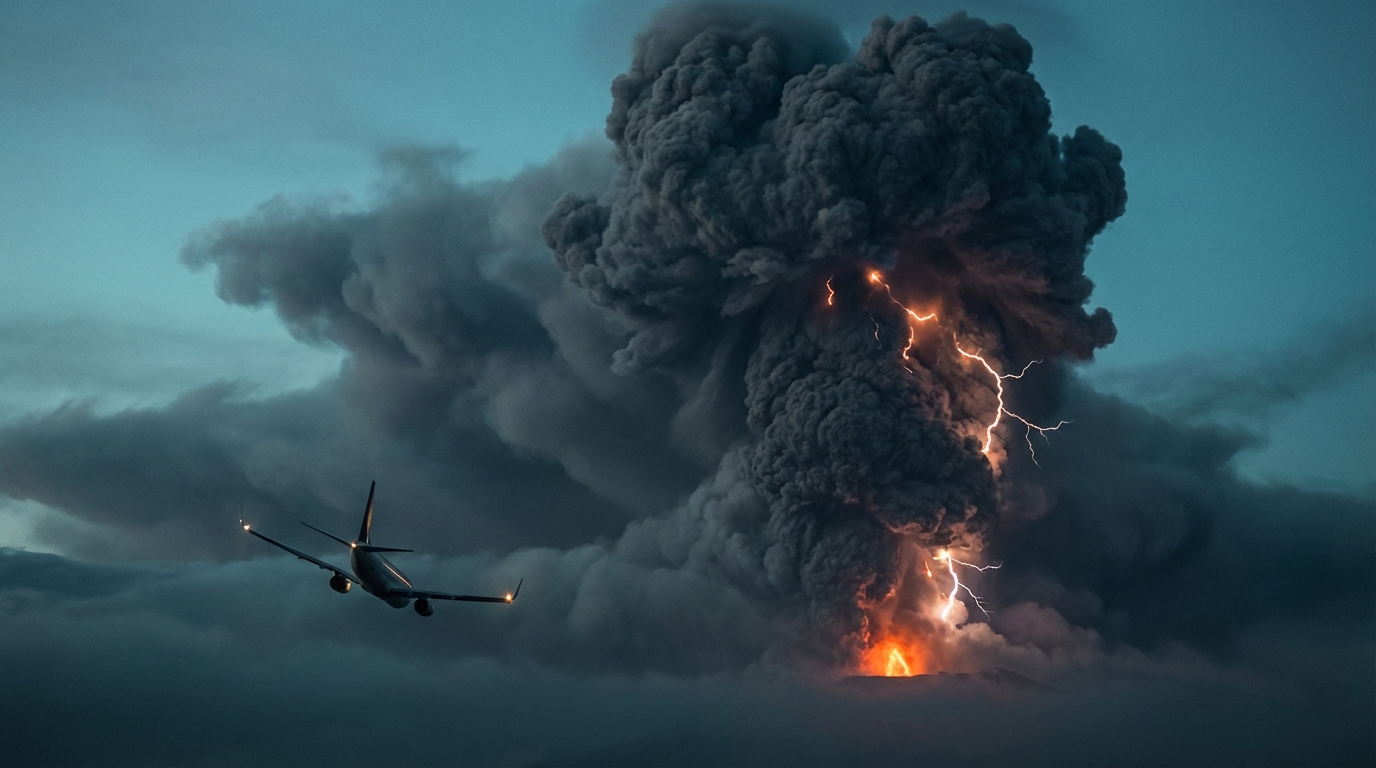
Shiveluch (Kamchatka Peninsula, Russia) generated the highest plume of the day, with KVERT reporting discrete explosive events sending ash to 7,900 meters (25,900 feet) above sea level at 00:15 UTC. The volcano, one of Kamchatka’s largest and most active, continues dome growth at its lava dome complex, with ash drifting northeast from the summit. Aviation Color Code remains Orange, indicating ongoing eruption with minor ash emission possible at any time.
Sangay (Ecuador) produced sustained ash emissions reaching 6,400 meters (21,000 feet) according to IG-EPN monitoring data timestamped 03:00 UTC. Located within the Cordillera Real of the Ecuadorian Andes, Sangay’s near-constant activity created a drifting ash cloud moving west-southwest, posing hazards to local aviation routes between Quito and Guayaquil. The observatory noted incandescent material rolling down the southeast flank concurrent with the ash emission.
Semeru (East Java, Indonesia) erupted at 01:00 UTC, sending an ash column to 4,600 meters (15,100 feet) above the summit as reported by PVMBG. The volcano’s Jonggring Seloko crater produced pyroclastic flows and incandescent avalanches extending 500-800 meters down the Kobokan drainage. Ash drifted toward the north and northwest, affecting agricultural areas in the Lumajang regency while triggering Level III (Siaga) alert status.
Fuego (Guatemala) generated explosive activity at 04:30 UTC, with INSIVUMEH (Instituto Nacional de Sismología, Vulcanología, Meteorología e Hidrología) recording ash heights of 4,300 meters (14,100 feet) above sea level. The stratovolcano produced 8-12 moderate explosions per hour, generating shock waves audible within 15 kilometers and depositing ash on nearby communities including Panimaché, Morelia, and Sangre de Cristo.
How High Are the Ash Clouds Rising?
Today’s reported ash altitudes place these volcanic emissions squarely within commercial aviation flight corridors. Shiveluch’s plume reached the upper troposphere at 7,900 meters, intersecting with cruise altitudes for trans-Pacific routes, while Sangay’s 6,400-meter column affects lower flight levels common to regional South American carriers. At these altitudes, volcanic ash poses severe risks to jet engines, as the silicate particles can melt inside hot sections and accrete on turbine blades. Meteorological models from the Volcanic Ash Advisory Centers (VAACs) indicate that Shiveluch’s ash is tracking northeast toward the Bering Sea, while Sangay’s plume dissipates over the Pacific Ocean west of the Andean cordillera.
What Should Aviation Authorities Know?
The Volcanic Ash Advisory Centers in Tokyo, Anchorage, and Washington have issued multiple SIGMETs (Significant Meteorological Information) regarding today’s activity. Shiveluch’s emissions threaten North Pacific routes connecting Asia to North America, potentially requiring reroutes through southern Alaska. Pilots should note that ash clouds are not detectable by standard aircraft weather radar and require satellite-based monitoring. The International Air Transport Association (IATA) recommends maintaining vertical separation of at least 600 meters from reported ash layers, though horizontal avoidance of 100 nautical miles or more provides greater safety margins for prolonged exposure risks.
Which Other Volcanoes Are Showing Unrest?
Beyond the four major ash producers, monitoring agencies tracked elevated activity at Taal, Mayon, and Canlaon in the Philippines, where PHIVOLCS maintains Alert Level 1 status indicating abnormal conditions. Sakurajima in Japan’s Kagoshima Prefecture continued its persistent Vulcanian eruptions, while Reventador in Ecuador and Sabancaya in Peru generated thermal anomalies detectable by satellite. Indonesia’s Dukono and Ibu maintained continuous low-level ash emissions typical of their ongoing eruptive phases, contributing to the global tally of 24 volcanic events recorded by the Smithsonian Global Volcanism Program.
Active Volcano Summary Table
| Volcano | Location | Event Type | Alert Level |
|---|---|---|---|
| Shiveluch | Russia | Ash Advisory | Orange |
| Sangay | Ecuador | Ash Advisory | Orange |
| Semeru | Indonesia | Ash Advisory | Level III (Siaga) |
| Fuego | Guatemala | Ash Advisory | Orange |
| Taal | Philippines | Volcanic Unrest | Level 1 |
| Mayon | Philippines | Volcanic Unrest | Level 1 |
| Canlaon | Philippines | Volcanic Unrest | Level 0 |
| Sakurajima | Japan | Explosive Eruption | Level 2 (Do Not Approach) |
| Reventador | Ecuador | Strombolian Activity | Orange |
| Sabancaya | Peru | Explosive Activity | Orange |
| Dukono | Indonesia | Continuous Ash | Level II (Waspada) |
| Ibu | Indonesia | Lava Flow/Ash | Level II (Waspada) |
Frequently Asked Questions
What is an aviation ash advisory?
An aviation ash advisory is an official notification issued by Volcanic Ash Advisory Centers (VAACs) when volcanic eruptions produce ash clouds that may affect aircraft operations. These advisories specify the location, altitude, and movement of ash clouds, enabling airlines and air traffic control to reroute flights and avoid engine damage or complete power loss caused by volcanic glass particles ingested into jet turbines.
How far can volcanic ash travel from its source?
Volcanic ash can travel thousands of kilometers from the erupting volcano, depending on eruption intensity, ash particle size, and atmospheric wind patterns. Fine ash particles (less than 2 millimeters) can remain suspended in the atmosphere for weeks and circle the globe, as demonstrated by the 2010 Eyjafjallajökull eruption, while coarse ash typically settles within hundreds of kilometers of the volcano within hours to days.
Should communities near these volcanoes prepare for evacuation?
Residents within 10-15 kilometers of Fuego, Semeru, and Sangay should remain prepared for rapid evacuation, as these volcanoes have demonstrated capability for pyroclastic flows and lahars that can reach populated areas within minutes. Local emergency management agencies in Guatemala, Indonesia, and Ecuador maintain evacuation routes and shelters; residents should monitor official alerts from INSIVUMEH, PVMBG, or IG-EPN rather than relying solely on visual observations of the volcano.
Track this event live on the map!
Download GeoShake and get instant earthquake alerts.
Download GeoShake