Global volcanic monitoring networks documented 23 distinct eruptive events across the Pacific Ring of Fire during the 24-hour period ending April 12, 2026, with five major volcanoes generating significant ash columns requiring aviation advisories according to the Smithsonian Global Volcanism Program. The distributed nature of today’s activity—spanning from Southeast Asia through Central America—highlights the persistent volcanic volatility along tectonic plate boundaries and demonstrates the continuous monitoring required by international aviation and emergency management agencies.
Which Volcanoes Erupted Today?
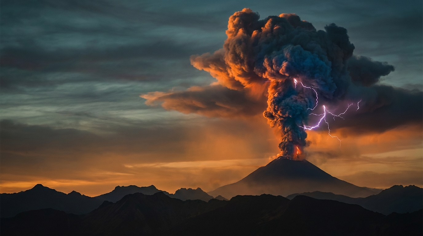
Santiaguito dome complex in Guatemala’s western highlands entered an intensified eruptive phase, generating pyroclastic flows and ash venting from the Caliente dome that were detected by regional seismic networks and satellite thermal sensors according to INSIVUMEH (Instituto Nacional de Sismología, Vulcanología, Meteorología e Hidrología). Ecuador’s Sangay stratovolcano produced substantial explosive activity beginning late April 11, ejecting dense ash clouds that prompted immediate warnings from the Washington Volcanic Ash Advisory Center for trans-Andean airspace.
Indonesia’s Semeru volcano, situated on Java’s eastern flank, maintained its persistent eruptive sequence with ash emissions reaching significant aviation altitudes, as reported by the Darwin VAAC. Simultaneously, Ecuador’s Reventador and Guatemala’s Fuego volcanoes produced comparable explosive regimens, with both stratovolcanoes generating ash-rich eruption columns visible on multispectral satellite imagery and detected by regional infrasound monitoring arrays.
How High Did the Ash Clouds Rise?
Altitude measurements derived from satellite stereoscopic analysis and pilot reports reveal substantial variation in eruption intensity across the monitored systems. Sangay registered the highest plume elevation at 6,100 meters (20,013 feet) above sea level, penetrating the upper troposphere and creating significant hazards for commercial aviation corridors traversing northern South America. Semeru and Reventador generated nearly identical column heights of 4,600 meters (15,092 feet), while Fuego produced slightly lower but still hazardous emissions at 4,300 meters (14,108 feet).
These measurements indicate that all four volcanoes produced sufficient ash volume and column momentum to trigger international aviation color codes and active rerouting protocols. The 6,100-meter Sangay plume represents particular concern as it approaches typical cruising flight levels for long-haul commercial jet traffic and may encounter jet stream winds capable of transporting ash particles hundreds of kilometers downwind according to atmospheric dispersion models.
Where Are the Aviation Hazards Concentrated?
The convergence of simultaneous ash advisories across multiple Volcanic Ash Advisory Center regions created complex airspace management challenges requiring international coordination on April 12. The Darwin VAAC maintained active warnings for Semeru’s drifting ash clouds, potentially affecting high-density routes between Indonesia, Australia, and Southeast Asian hubs. Meanwhile, the Washington VAAC issued overlapping advisories for Ecuador’s dual volcanic threats—Sangay and Reventador—creating navigational constraints for flights traversing the Andes between North and South America.
Guatemala’s Fuego volcano added Central American complexity to the aviation picture, with ash drift patterns potentially impacting routes connecting Mexico City, Panama, and Caribbean destinations. Pilots operating within these regions must maintain continuous communication with meteorological watch offices and consider fuel-intensive alternate routing to avoid engine-damaging volcanic ash particles, which can melt and accumulate within turbine blades causing catastrophic power loss.
Which Regions Face the Greatest Risk?
Ecuador emerges as April 12’s highest-concern region, simultaneously hosting two active volcanoes producing substantial ash columns within its relatively compact territory. The combination of Sangay’s 6,100-meter plume and Reventador’s persistent 4,600-meter activity creates overlapping hazard zones that challenge the Instituto Geofísico’s monitoring resources and emergency response capabilities. Indonesia maintains significant concern levels with Semeru’s continued explosive behavior on densely populated Java, representing ongoing threats to local agricultural communities and regional aviation infrastructure.
Secondary monitoring priorities include the Philippines, where Mayon and Canlaon volcanoes show signs of magmatic unrest requiring close observation by PHIVOLCS (Philippine Institute of Volcanology and Seismology). Japan’s Sakurajima continues its typical active regimen under the watchful eye of JMA (Japan Meteorological Agency), while Indonesia’s Marapi, Dukono, and Ibu, along with Peru’s Sabancaya, contribute to the global tally of thermal anomalies and volcanic gas emissions detected by NOAA’s Suomi NPP and NASA’s Terra satellites.
Volcanic Activity Summary Table
| Volcano | Location | Event Type | Alert Level |
|---|---|---|---|
| Sangay | Ecuador | Ash Advisory | Orange |
| Semeru | Indonesia | Ash Advisory | Level II (Waspada) |
| Reventador | Ecuador | Ash Advisory | Orange |
| Fuego | Guatemala | Ash Advisory | Orange |
| Santiaguito | Guatemala | Eruption | Orange |
| Mayon | Philippines | Volcanic Unrest | Alert Level 2 |
| Canlaon | Philippines | Monitoring | Alert Level 1 |
| Sakurajima | Japan | Minor Eruption | Level 3 (Alert) |
| Marapi | Indonesia | Eruption | Level II (Waspada) |
| Dukono | Indonesia | Eruption | Level II (Waspada) |
| Ibu | Indonesia | Eruption | Level II (Waspada) |
| Sabancaya | Peru | Ash Emissions | Orange |
Data compiled from Smithsonian Global Volcanism Program, USGS, and local monitoring agencies (PVMBG, IG-EPN, INSIVUMEH, PHIVOLCS). Alert levels represent current status as of April 12, 2026.
Frequently Asked Questions
What causes volcanic ash to reach such high altitudes?
Explosive volcanic eruptions generate ash columns through a combination of magmatic gas expansion and rapid heat transfer to atmospheric air. When high-pressure magma encounters groundwater or experiences rapid decompression, the violent expansion of dissolved gases creates a buoyant plume that can propel ash particles tens of thousands of feet into the atmosphere. The heat and kinetic energy from these explosions establish convection currents that sustain column rise until atmospheric density equals plume density, with today’s measurements of 6,100 meters representing significant energy release capable of penetrating commercial flight levels.
How do pilots avoid volcanic ash clouds?
Commercial aviation relies on a global network of nine Volcanic Ash Advisory Centers (VAACs) that track ash plumes using geostationary and polar-orbiting satellite data, ground-based weather radar, and pilot visual observations. Flight crews receive real-time updates through SIGMETs (Significant Meteorological Information) and NOTAMs (Notices to Airmen), adjusting flight paths to circumnavigate contaminated airspace by at least 100 nautical miles horizontally. Modern volcanic ash avoidance strategies prioritize prevention over penetration, as volcanic ash can melt and accumulate within jet engine hot sections, causing surge, stall, and complete power loss, as demonstrated during the 1989 Mount Redoubt incident and 2010 Eyjafjallajökull airspace closure.
Should travelers be concerned about these eruptions?
While the current eruptions present significant aviation hazards requiring flight rerouting, they primarily affect high-altitude air traffic rather than ground-level tourist destinations at current activity levels. However, travelers within 10-20 kilometers of active volcanoes should maintain awareness of local evacuation protocols, as ashfall can disrupt ground transportation, contaminate water supplies, and cause respiratory distress. Visitors to volcanic regions should carry N95 masks, protect electronic equipment from abrasive ash particles, and heed all evacuation orders from local monitoring agencies such as Indonesia’s PVMBG or Ecuador’s IGEPN, as volcanic activity can escalate rapidly with little warning.
Track this event live on the map!
Download GeoShake and get instant earthquake alerts.
Download GeoShake