Global volcanic activity remained elevated throughout the past 24 hours, with the Smithsonian Global Volcanism Program documenting approximately 25 discrete eruptive events across the Pacific Ring of Fire. The most significant developments include high-altitude ash emissions from Russia’s Shiveluch reaching 9,100 meters, sustained explosive activity at Ecuador’s Sangay, and multiple ash advisories affecting Indonesian airspace. According to reports compiled by the Smithsonian GVP and various Volcanic Ash Advisory Centers (VAACs), aviation authorities have issued alerts for ash clouds reaching commercial flight levels.
Which Volcanoes Generated Ash Advisories Today?
Four volcanoes prompted formal ash advisories due to emissions reaching concerning altitudes for aviation. Shiveluch, located on Russia’s Kamchatka Peninsula, produced the highest plume of the day, with ash reported at 9,100 meters (29,900 feet) above sea level according to the Tokyo VAAC. This stratovolcano, one of Kamchatka’s largest and most active, generated a substantial ash cloud that drifted northeastward, posing potential hazards to trans-Pacific flight routes.
In Ecuador, Sangay volcano registered an ash advisory with plume heights reaching 7,000 meters (23,000 feet). The Washington VAAC reported continuous emissions from this remote stratovolcano, which has maintained high levels of activity throughout 2026. Meanwhile, Indonesia’s Semeru volcano on Java island produced ash to 4,600 meters (15,100 feet), according to Darwin VAAC observations, while Dukono in the Moluccas generated lower-level emissions at 3,000 meters (9,800 feet).
Where Are Explosive Eruptions Occurring?
Beyond ash advisories, explosive eruptive activity continues at several notable volcanoes monitored by local geological agencies. Fuego volcano in Guatemala entered an active eruptive phase, with INSIVUMEH reporting lava flows and explosive activity producing ash plumes. This stratovolcano, known for its frequent Strombolian activity, generated pyroclastic flows and ashfall affecting communities south of the summit.
The Philippines’ Mayon and Canlaon volcanoes both show signs of unrest, with PHIVOLCS maintaining elevated alert levels due to lava dome growth and seismic swarms respectively. In Mexico, Popocatépetl continued its persistent low-level eruptive behavior with minor ash emissions, while Peru’s Sabancaya and Ecuador’s Reventador maintained moderate explosive activity with incandescent ejecta. Indonesia’s arc shows particularly high thermal activity, with Dempo, Ibu, and Lewotolo all recording summit eruptions according to PVMBG monitoring networks.
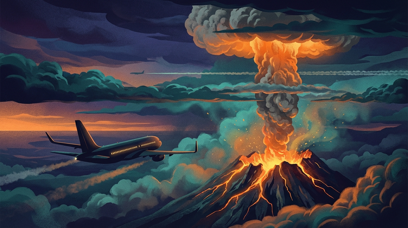
How Do Today’s Ash Plumes Affect Aviation?
The altitude of volcanic ash determines its intersection with commercial air traffic, and today’s emissions present distinct aviation hazards across multiple flight levels. Shiveluch’s 9,100-meter plume penetrates the upper troposphere, directly intersecting trans-Pacific jet routes at cruising altitudes between FL250 and FL400. Volcanic ash at these heights can cause engine flameout, abrasion of windshields, and contamination of aircraft systems.
Sangay’s 7,000-meter emission affects medium-haul routes across northern South America, while Semeru’s 4,600-meter plume primarily impacts domestic Indonesian flights and lower-altitude general aviation. The Darwin VAAC has specifically warned that ash from Indonesian volcanoes may be difficult to distinguish meteorologically, requiring enhanced pilot vigilance and real-time satellite monitoring. Aircraft encountering these conditions must execute avoidance maneuvers, typically requiring altitude changes of several thousand feet or lateral diversions exceeding 100 nautical miles from the ash cloud boundaries.
What Is the Current Alert Level Status?
Local monitoring agencies have assigned various alert levels to today’s active volcanoes based on seismicity, deformation, and eruptive intensity. The following table summarizes the current status of volcanoes showing significant activity during the 24-hour reporting period:
| Volcano | Location | Event Type | Alert Level |
|---|---|---|---|
| Shiveluch | Kamchatka Peninsula, Russia | Ash Advisory | Orange (Watch) |
| Sangay | Ecuador | Ash Advisory | Orange |
| Semeru | Indonesia | Ash Advisory | Level III (Siaga) |
| Fuego | Guatemala | Eruption | Red/Orange |
| Dukono | Indonesia | Ash Advisory | Level II (Waspada) |
| Reventador | Ecuador | Eruption | Orange |
| Mayon | Philippines | Eruption | Alert Level 2 |
| Popocatépetl | Mexico | Eruption | Yellow Phase 2 |
| Sabancaya | Peru | Eruption | Orange |
| Canlaon | Philippines | Eruption | Alert Level 1 |
| Dempo | Indonesia | Eruption | Level II (Waspada) |
| Ibu | Indonesia | Eruption | Level II (Waspada) |
| Lewotolo | Indonesia | Eruption | Level II (Waspada) |
Frequently Asked Questions
What is a volcanic ash advisory and why is it issued?
A volcanic ash advisory is an official notification issued by a Volcanic Ash Advisory Center (VAAC) when a volcano produces ash clouds that could affect aircraft operations. These advisories include critical data such as ash cloud height, movement direction, and estimated concentration, enabling airlines and air traffic control to reroute flights and prevent dangerous encounters with volcanic particles that can severely damage jet engines.
How high must volcanic ash reach to affect commercial flights?
Commercial airliners typically cruise between 9,000 and 12,000 meters (30,000 to 40,000 feet), so any volcanic ash exceeding 6,000 meters (20,000 feet) poses a significant threat to high-altitude flight paths. However, ash below these altitudes remains dangerous for takeoff, landing, and general aviation aircraft, requiring temporary airport closures and ground stops in affected regions.
Should residents near active volcanoes be concerned about today’s activity?
While today’s ash advisories primarily target aviation concerns, residents within 10-20 kilometers of volcanoes like Fuego, Semeru, and Shiveluch should remain vigilant for potential ashfall, lahars, and pyroclastic flows. Local emergency management agencies typically coordinate evacuations when alert levels reach Red or Level IV, but communities should maintain emergency supply kits and follow official guidance from geological services such as USGS, PHIVOLCS, or PVMBG.
Track this event live on the map!
Download GeoShake and get instant earthquake alerts.
Download GeoShake